Nangabere geodata
Nangabere (East Nusa Tenggara) is a seat of a fourth-order administrative division; located in Indonesia in Asia/Makassar (GMT+8) time zone. In our database, there are 407 cities with bigger population. Compared to other cities in Indonesia, 91.7% of cities are located further ↑North; 82.6% of cities are located further ←West and 58.6% of cities have higher elevation than Nangabere. Note1


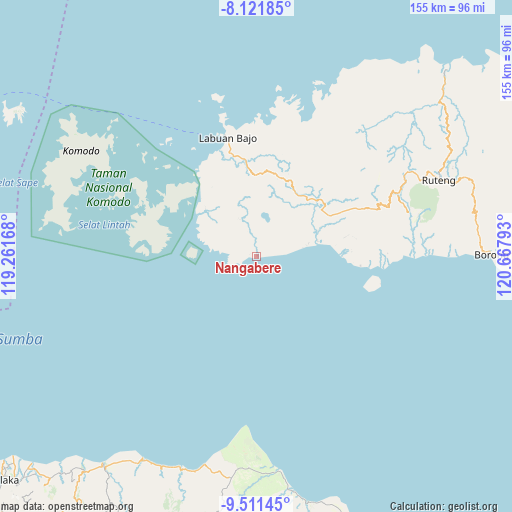
Nangabere GPS coordinates[2]
8° 49' 2.28" South, 119° 57' 53.28" East
| Map corner | latitude | longitude |
|---|---|---|
| Upper-left | -8.12185°, | 119.26168° |
| Center: | -8.8173°, | 119.9648° |
| Lower-right: | -9.51145°, | 120.66793° |
| Map W x H: | 154.5×154.5 km | = 96×96mi |
| max Lat: | 5.88969° ⇑91.7% North |
| Nangabere: | -8.8173° |
| min Lat: | ⇓8.3% South -10.934° |
| min Long | Nangabere | max Long |
| 95.1345° | 119.9648° | 140.9419° |
| W 82.6%⇐ | ⇒17.4% E |
Elevation
Elevation of Nangabere is 65 m = 213 ft, and this is 164.7 m = 540 ft below average elevation for this country.
| Max E: |
3185 m = 10449 ft | 58.6% |
| Avg. | 229.7 m = 754 ft | |
| Nangabere | 65 m = 213 ft | |
Min E: |
-1 m = -3 ft | 41.4% |
See also: Indonesia elevation on elevation.city.
Geographical zone
Nangabere is located in South Torrid zone (between Equator and Tropic of Capricorn). Distance of Equator is 980.4 km =609.2 mi to North.| Distance of | km | miles | from Nangabere |
|---|---|---|---|
| Equator | 980.4 | 609.2 | to North |
| Tropic Capricorn | 1625.5 | 1010 | to South |
| Antarctic Circle | 6420.8 | 3989.7 | to South |
| South Pole | 9026.7 | 5608.9 | to South |


Nearby cities:
15 places around Nangabere: (largest is in red/bold)
• Bambor
25 km =15.5 mi,  24°
24°
• Dahot
22.3 km =13.9 mi,  32°
32°
• Golondalas
25.5 km =15.8 mi,  13°
13°
• Kenari
26 km =16.2 mi,  328°
328°
• Laci
20.8 km =12.9 mi,  48°
48°
• Melo
24.4 km =15.2 mi,  359°
359°
• Nangalili
18.8 km =11.7 mi,  76°
76°
• Ndewel
27.5 km =17.1 mi, 19°
• Nunang
11.6 km =7.2 mi, 21°
• Rambang
20.8 km =12.9 mi, 25°
• Ranggawatu
24.4 km =15.2 mi, 20°
• Tao
21.1 km =13.1 mi,  312°
312°
• Teongtoda
19.8 km =12.3 mi, 12°
• Tondongraja
28 km =17.4 mi, 21°
• Werang
19.4 km =12.1 mi, 15°
Sources, notices
• [Note1] Compared only with cities in Indonesia existing in our database
• [Src1] Map data: © OpenStreetMap contributors (CC-BY-SA)
• [Src2] Other city data from geonames.org with taken over terms of usage.
• [Src3] Geographical zone / Annual Mean Temperature by Robert A. Rohde @ Wikipedia
