Ongko geodata
Ongko (West Nusa Tenggara) is a seat of a fourth-order administrative division; located in Indonesia in Asia/Makassar (GMT+8) time zone. In our database, there are 407 cities with bigger population. Compared to other cities in Indonesia, 90.2% of cities are located further ↑North; 79.4% of cities are located further ←West and 68.4% of cities have higher elevation than Ongko. Note1


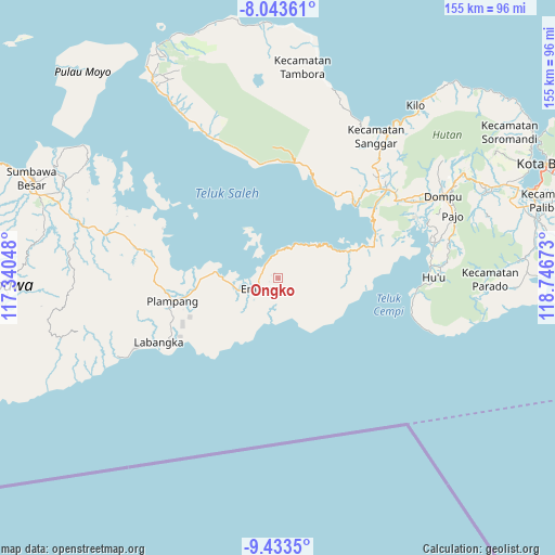
Ongko GPS coordinates[2]
8° 44' 21.12" South, 118° 2' 36.96" East
| Map corner | latitude | longitude |
|---|---|---|
| Upper-left | -8.04361°, | 117.34048° |
| Center: | -8.7392°, | 118.0436° |
| Lower-right: | -9.4335°, | 118.74673° |
| Map W x H: | 154.5×154.5 km | = 96×96mi |
| max Lat: | 5.88969° ⇑90.2% North |
| Ongko: | -8.7392° |
| min Lat: | ⇓9.8% South -10.934° |
| min Long | Ongko | max Long |
| 95.1345° | 118.0436° | 140.9419° |
| W 79.4%⇐ | ⇒20.6% E |
Elevation
Elevation of Ongko is 35 m = 115 ft, and this is 194.7 m = 639 ft below average elevation for this country.
| Max E: |
3185 m = 10449 ft | 68.4% |
| Avg. | 229.7 m = 754 ft | |
| Ongko | 35 m = 115 ft | |
Min E: |
-1 m = -3 ft | 31.6% |
See also: Indonesia elevation on elevation.city.
Geographical zone
Ongko is located in South Torrid zone (between Equator and Tropic of Capricorn). Distance of Equator is 971.7 km =603.8 mi to North.| Distance of | km | miles | from Ongko |
|---|---|---|---|
| Equator | 971.7 | 603.8 | to North |
| Tropic Capricorn | 1634.2 | 1015.4 | to South |
| Antarctic Circle | 6429.5 | 3995.1 | to South |
| South Pole | 9035.4 | 5614.3 | to South |


Nearby cities:
15 places around Ongko: (largest is in red/bold)
• Ampu
4.6 km =2.9 mi,  293°
293°
• Bantu
1.9 km =1.2 mi, 289°
• Boal Atas
10.6 km =6.6 mi,  236°
236°
• Kalate
31.3 km =19.4 mi,  45°
45°
• Kempo
31.3 km =19.4 mi, 45°
• Kesi
28.1 km =17.5 mi,  35°
35°
• Konte
30.1 km =18.7 mi, 44°
• Labuhanjambu
5.4 km =3.4 mi,  332°
332°
• Mekarjaya
32.1 km =19.9 mi, 239°
• Parang
6.9 km =4.3 mi,  265°
265°
• Pisangkemeng
30.1 km =18.7 mi,  256°
256°
• Plampang
29.8 km =18.5 mi, 257°
• Rasabou
32.3 km =20.1 mi, 45°
• Soro
29.4 km =18.3 mi, 46°
• Teluksantong
17.2 km =10.7 mi,  276°
276°
Sources, notices
• [Note1] Compared only with cities in Indonesia existing in our database
• [Src1] Map data: © OpenStreetMap contributors (CC-BY-SA)
• [Src2] Other city data from geonames.org with taken over terms of usage.
• [Src3] Geographical zone / Annual Mean Temperature by Robert A. Rohde @ Wikipedia
