Pulo Ie geodata
Pulo Ie (Aceh) is a seat of a third-order administrative division; located in Indonesia in Asia/Jakarta (GMT+7) time zone. In our database, there are 407 cities with bigger population. Compared to other cities in Indonesia, 98.1% of cities are located further ↓South; 98.9% of cities are located further →East and 70.9% of cities have lower elevation than Pulo Ie. Note1


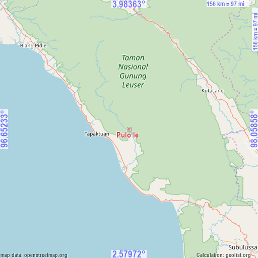
Pulo Ie GPS coordinates[2]
3° 16' 54.912" North, 97° 21' 19.62" East
| Map corner | latitude | longitude |
|---|---|---|
| Upper-left | 3.98363°, | 96.65233° |
| Center: | 3.28192°, | 97.35545° |
| Lower-right: | 2.57972°, | 98.05858° |
| Map W x H: | 156.1×156.1 km | = 97×97mi |
| max Lat: | 5.88969° ⇑1.9% North |
| Pulo Ie: | 3.28192° |
| min Lat: | ⇓98.1% South -10.934° |
| min Long | Pulo Ie | max Long |
| 95.1345° | 97.35545° | 140.9419° |
| W 1.1%⇐ | ⇒98.9% E |
Elevation
Elevation of Pulo Ie is 304 m = 997 ft, and this is 74.3 m = 244 ft above average elevation for this country.
| Max E: |
3185 m = 10449 ft | 29.1% |
| Pulo Ie | 304 m 997 ft | |
| Avg. | 229.7 m = 754 ft | |
Min E: |
-1 m = -3 ft | 70.9% |
See also: Indonesia elevation on elevation.city.
Geographical zone
Pulo Ie is located in North Torrid zone (between Equator and Tropic of Cancer). Distance of Equator is 364.9 km =226.7 mi to South.| Distance of | km | miles | from Pulo Ie |
|---|---|---|---|
| North Pole | 9642.1 | 5991.3 | to North |
| Arctic Circle | 7036.3 | 4372.2 | to North |
| Tropic Cancer | 2241 | 1392.5 | to North |
| Equator | 364.9 | 226.7 | to South |


Nearby cities:
15 places around Pulo Ie: (largest is in red/bold)
• Bakungan
42.2 km =26.2 mi,  160°
160°
• Bambol
61.1 km =38 mi,  72°
72°
• Kota Trieng
56 km =34.8 mi,  308°
308°
• Mersak
26 km =16.2 mi,  6°
6°
• Meukek
39 km =24.2 mi,  303°
303°
• Ngkan
37.2 km =23.1 mi, 69°
• Paya Dapur
10.6 km =6.6 mi,  139°
139°
• Peuleumat
45.2 km =28.1 mi, 307°
• Pulopaya
56.1 km =34.9 mi, 144°
• Samadua
25.6 km =15.9 mi,  283°
283°
• Sawang
31.3 km =19.4 mi, 295°
• Seupakat
41.9 km =26 mi,  16°
16°
• Suak Bakung
30.7 km =19.1 mi,  178°
178°
• Tanah Merah
54.8 km =34.1 mi,  44°
44°
• Terbangan
11.9 km =7.4 mi,  231°
231°
Sources, notices
• [Note1] Compared only with cities in Indonesia existing in our database
• [Src1] Map data: © OpenStreetMap contributors (CC-BY-SA)
• [Src2] Other city data from geonames.org with taken over terms of usage.
• [Src3] Geographical zone / Annual Mean Temperature by Robert A. Rohde @ Wikipedia
