Paya Dapur geodata
Paya Dapur (Aceh) is a seat of a third-order administrative division; located in Indonesia in Asia/Jakarta (GMT+7) time zone. In our database, there are 407 cities with bigger population. Compared to other cities in Indonesia, 98.1% of cities are located further ↓South; 98.8% of cities are located further →East and 63.5% of cities have lower elevation than Paya Dapur. Note1


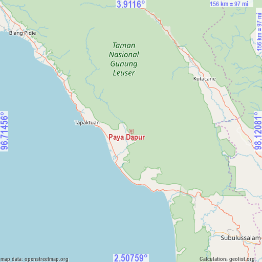
Paya Dapur GPS coordinates[2]
3° 12' 35.424" North, 97° 25' 3.648" East
| Map corner | latitude | longitude |
|---|---|---|
| Upper-left | 3.9116°, | 96.71456° |
| Center: | 3.20984°, | 97.41768° |
| Lower-right: | 2.50759°, | 98.12081° |
| Map W x H: | 156.1×156.1 km | = 97×97mi |
| max Lat: | 5.88969° ⇑1.9% North |
| Paya Dapur: | 3.20984° |
| min Lat: | ⇓98.1% South -10.934° |
| min Long | Paya Dapur | max Long |
| 95.1345° | 97.41768° | 140.9419° |
| W 1.2%⇐ | ⇒98.8% E |
Elevation
Elevation of Paya Dapur is 202 m = 663 ft, and this is 27.7 m = 91 ft below average elevation for this country.
| Max E: |
3185 m = 10449 ft | 36.5% |
| Avg. | 229.7 m = 754 ft | |
| Paya Dapur | 202 m = 663 ft | |
Min E: |
-1 m = -3 ft | 63.5% |
See also: Indonesia elevation on elevation.city.
Geographical zone
Paya Dapur is located in North Torrid zone (between Equator and Tropic of Cancer). Distance of Equator is 356.9 km =221.8 mi to South.| Distance of | km | miles | from Paya Dapur |
|---|---|---|---|
| North Pole | 9650.2 | 5996.4 | to North |
| Arctic Circle | 7044.3 | 4377.1 | to North |
| Tropic Cancer | 2249 | 1397.5 | to North |
| Equator | 356.9 | 221.8 | to South |


Nearby cities:
15 places around Paya Dapur: (largest is in red/bold)
• Bakungan
32.6 km =20.3 mi,  167°
167°
• Bambol
57.8 km =35.9 mi,  62°
62°
• Krueng Luak
54.4 km =33.8 mi,  135°
135°
• Mersak
34.1 km =21.2 mi,  353°
353°
• Meukek
49.3 km =30.6 mi,  306°
306°
• Ngkan
35.1 km =21.8 mi,  52°
52°
• Peuleumat
55.6 km =34.5 mi, 309°
• Pulo Ie
10.6 km =6.6 mi,  319°
319°
• Pulopaya
45.5 km =28.3 mi,  145°
145°
• Samadua
34.8 km =21.6 mi,  293°
293°
• Sawang
41.2 km =25.6 mi,  301°
301°
• Seupakat
48.5 km =30.1 mi,  5°
5°
• Suak Bakung
23.5 km =14.6 mi,  194°
194°
• Tanah Merah
56.6 km =35.2 mi,  33°
33°
• Terbangan
16.2 km =10.1 mi,  272°
272°
Sources, notices
• [Note1] Compared only with cities in Indonesia existing in our database
• [Src1] Map data: © OpenStreetMap contributors (CC-BY-SA)
• [Src2] Other city data from geonames.org with taken over terms of usage.
• [Src3] Geographical zone / Annual Mean Temperature by Robert A. Rohde @ Wikipedia
