Meukek geodata
Meukek (Aceh) is a seat of a third-order administrative division; located in Indonesia in Asia/Jakarta (GMT+7) time zone. In our database, there are 407 cities with bigger population. Compared to other cities in Indonesia, 98.3% of cities are located further ↓South; 99% of cities are located further →East and 66.1% of cities have higher elevation than Meukek. Note1


Meukek GPS coordinates[2]
3° 28' 33.888" North, 97° 3' 44.46" East
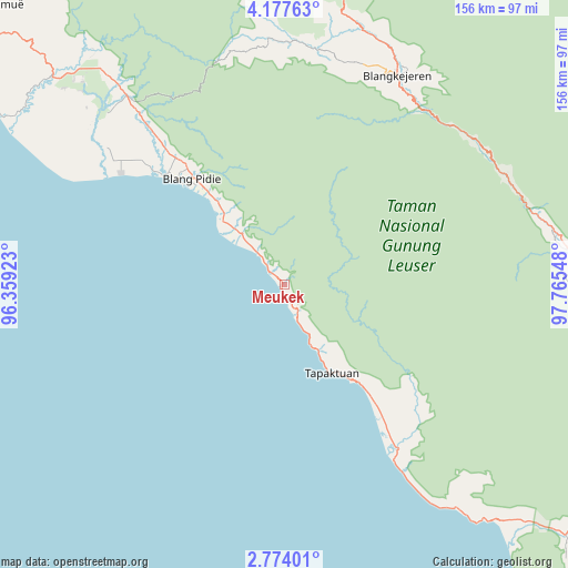
| Map corner | latitude | longitude |
|---|---|---|
| Upper-left | 4.17763°, | 96.35923° |
| Center: | 3.47608°, | 97.06235° |
| Lower-right: | 2.77401°, | 97.76548° |
| Map W x H: | 156.1×156.1 km | = 97×97mi |
| max Lat: | 5.88969° ⇑1.7% North |
| Meukek: | 3.47608° |
| min Lat: | ⇓98.3% South -10.934° |
| min Long | Meukek | max Long |
| 95.1345° | 97.06235° | 140.9419° |
| W 1%⇐ | ⇒99% E |
Elevation
Elevation of Meukek is 40 m = 131 ft, and this is 189.7 m = 622 ft below average elevation for this country.
| Max E: |
3185 m = 10449 ft | 66.1% |
| Avg. | 229.7 m = 754 ft | |
| Meukek | 40 m = 131 ft | |
Min E: |
-1 m = -3 ft | 33.9% |
See also: Indonesia elevation on elevation.city.
Geographical zone
Meukek is located in North Torrid zone (between Equator and Tropic of Cancer). Distance of Equator is 386.5 km =240.2 mi to South.| Distance of | km | miles | from Meukek |
|---|---|---|---|
| North Pole | 9620.6 | 5978 | to North |
| Arctic Circle | 7014.7 | 4358.7 | to North |
| Tropic Cancer | 2219.4 | 1379.1 | to North |
| Equator | 386.5 | 240.2 | to South |


Nearby cities:
15 places around Meukek: (largest is in red/bold)
• Blangpidie
38.6 km =24 mi,  319°
319°
• Kota Trieng
17.5 km =10.9 mi, 320°
• Kotabahagia
50.4 km =31.3 mi, 319°
• Mersak
35.7 km =22.2 mi,  83°
83°
• Paya Dapur
49.3 km =30.6 mi,  126°
126°
• Peuleumat
6.7 km =4.2 mi,  328°
328°
• Pulo Ie
39 km =24.2 mi,  123°
123°
• Samadua
17.4 km =10.8 mi,  154°
154°
• Sawang
9.2 km =5.7 mi, 151°
• Seupakat
48.2 km =30 mi,  67°
67°
• Suak Bakung
62.1 km =38.6 mi, 147°
• Suek
42.9 km =26.7 mi, 320°
• Susoh
38.4 km =23.9 mi, 315°
• Tangantangancut
30.3 km =18.8 mi, 320°
• Terbangan
37.1 km =23.1 mi,  141°
141°
Sources, notices
• [Note1] Compared only with cities in Indonesia existing in our database
• [Src1] Map data: © OpenStreetMap contributors (CC-BY-SA)
• [Src2] Other city data from geonames.org with taken over terms of usage.
• [Src3] Geographical zone / Annual Mean Temperature by Robert A. Rohde @ Wikipedia
