Alue Glumpang geodata
Alue Glumpang (Aceh) is a seat of a third-order administrative division; located in Indonesia in Asia/Jakarta (GMT+7) time zone. In our database, there are 407 cities with bigger population. Compared to other cities in Indonesia, 99.5% of cities are located further ↓South; 99.3% of cities are located further →East and 60.3% of cities have higher elevation than Alue Glumpang. Note1


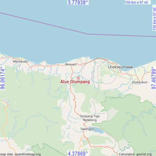
Alue Glumpang GPS coordinates[2]
5° 4' 45.912" North, 96° 45' 53.496" East
| Map corner | latitude | longitude |
|---|---|---|
| Upper-left | 5.77939°, | 96.06174° |
| Center: | 5.07942°, | 96.76486° |
| Lower-right: | 4.37869°, | 97.46799° |
| Map W x H: | 155.7×155.7 km | = 96.7×96.7mi |
| max Lat: | 5.88969° ⇑0.5% North |
| Alue Glumpang: | 5.07942° |
| min Lat: | ⇓99.5% South -10.934° |
| min Long | Alue Glumpang | max Long |
| 95.1345° | 96.76486° | 140.9419° |
| W 0.7%⇐ | ⇒99.3% E |
Elevation
Elevation of Alue Glumpang is 58 m = 190 ft, and this is 171.7 m = 563 ft below average elevation for this country.
| Max E: |
3185 m = 10449 ft | 60.3% |
| Avg. | 229.7 m = 754 ft | |
| Alue Glumpang | 58 m = 190 ft | |
Min E: |
-1 m = -3 ft | 39.7% |
See also: Indonesia elevation on elevation.city.
Geographical zone
Alue Glumpang is located in North Torrid zone (between Equator and Tropic of Cancer). Distance of Equator is 564.8 km =351 mi to South.| Distance of | km | miles | from Alue Glumpang |
|---|---|---|---|
| North Pole | 9442.3 | 5867.2 | to North |
| Arctic Circle | 6836.4 | 4247.9 | to North |
| Tropic Cancer | 2041.1 | 1268.3 | to North |
| Equator | 564.8 | 351 | to South |


Nearby cities:
15 places around Alue Glumpang: (largest is in red/bold)
• Adil Makmur
17.6 km =10.9 mi,  41°
41°
• Bireun
15.5 km =9.6 mi,  332°
332°
• Blang Ara
29.5 km =18.3 mi,  83°
83°
• Blang Mane
6.9 km =4.3 mi,  173°
173°
• Blangpulo
37.4 km =23.2 mi,  67°
67°
• Bulahblangaro
9.8 km =6.1 mi,  85°
85°
• Cot Baroh
17.3 km =10.7 mi,  29°
29°
• Juli
6.8 km =4.2 mi,  297°
297°
• Jumpangdua
13.2 km =8.2 mi,  9°
9°
• Kute Panang
47.7 km =29.6 mi,  184°
184°
• Lhokseumawe
44.2 km =27.5 mi, 75°
• Rusip
48.9 km =30.4 mi,  200°
200°
• Simpang Teritit
43.7 km =27.2 mi, 166°
• Simpang Tiga Redelong
41.5 km =25.8 mi,  163°
163°
• Uleeglee
47.7 km =29.6 mi,  285°
285°
Sources, notices
• [Note1] Compared only with cities in Indonesia existing in our database
• [Src1] Map data: © OpenStreetMap contributors (CC-BY-SA)
• [Src2] Other city data from geonames.org with taken over terms of usage.
• [Src3] Geographical zone / Annual Mean Temperature by Robert A. Rohde @ Wikipedia
