Bireun geodata
Bireun (Aceh) is a populated place; located in Indonesia in Asia/Jakarta (GMT+7) time zone. With population of 25,793 people, there are 348 cities with bigger population in this country. Compared to other cities in Indonesia, 99.7% of cities are located further ↓South; 99.3% of cities are located further →East and 79.9% of cities have higher elevation than Bireun. Note1


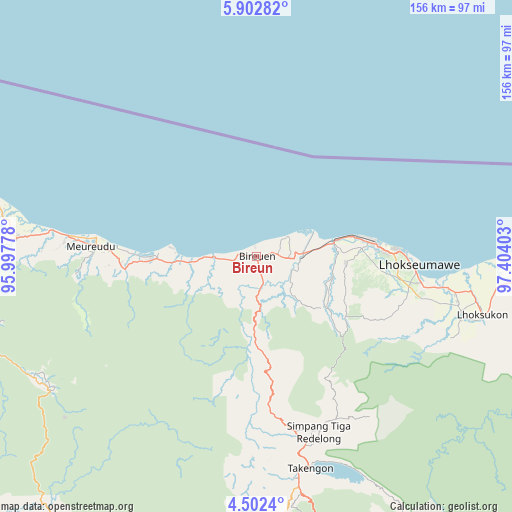
Bireun GPS coordinates[2]
5° 12' 10.8" North, 96° 42' 3.24" East
| Map corner | latitude | longitude |
|---|---|---|
| Upper-left | 5.90282°, | 95.99778° |
| Center: | 5.203°, | 96.7009° |
| Lower-right: | 4.5024°, | 97.40403° |
| Map W x H: | 155.7×155.7 km | = 96.7×96.7mi |
| max Lat: | 5.88969° ⇑0.3% North |
| Bireun: | 5.203° |
| min Lat: | ⇓99.7% South -10.934° |
| min Long | Bireun | max Long |
| 95.1345° | 96.7009° | 140.9419° |
| W 0.7%⇐ | ⇒99.3% E |
Elevation
Elevation of Bireun is 19 m = 62 ft, and this is 210.7 m = 691 ft below average elevation for this country.
| Max E: |
3185 m = 10449 ft | 79.9% |
| Avg. | 229.7 m = 754 ft | |
| Bireun | 19 m = 62 ft | |
Min E: |
-1 m = -3 ft | 20.1% |
See also: Indonesia elevation on elevation.city.
Geographical zone
Bireun is located in North Torrid zone (between Equator and Tropic of Cancer). Distance of Equator is 578.5 km =359.5 mi to South.| Distance of | km | miles | from Bireun |
|---|---|---|---|
| North Pole | 9428.5 | 5858.6 | to North |
| Arctic Circle | 6822.7 | 4239.4 | to North |
| Tropic Cancer | 2027.4 | 1259.8 | to North |
| Equator | 578.5 | 359.5 | to South |


Nearby cities:
15 places around Bireun: (largest is in red/bold)
• Adil Makmur
18.7 km =11.6 mi,  91°
91°
• Alue Glumpang
15.5 km =9.6 mi,  152°
152°
• Blang Ara
37.8 km =23.5 mi,  105°
105°
• Blang Mane
22.1 km =13.7 mi,  159°
159°
• Blangpulo
41.7 km =25.9 mi, 89°
• Bulahblangaro
21.2 km =13.2 mi,  127°
127°
• Cot Baroh
15.6 km =9.7 mi,  84°
84°
• Juli
10.6 km =6.6 mi,  174°
174°
• Jumpangdua
9.3 km =5.8 mi, 94°
• Lhokseumawe
49.9 km =31 mi, 92°
• Reuleuet
46.3 km =28.8 mi,  271°
271°
• Simpang Tiga Redelong
56.8 km =35.3 mi, 160°
• Trienggadeng
55.4 km =34.4 mi, 274°
• Ulee Gle
41.4 km =25.7 mi, 270°
• Uleeglee
39 km =24.2 mi, 267°
Sources, notices
• [Note1] Compared only with cities in Indonesia existing in our database
• [Src1] Map data: © OpenStreetMap contributors (CC-BY-SA)
• [Src2] Other city data from geonames.org with taken over terms of usage.
• [Src3] Geographical zone / Annual Mean Temperature by Robert A. Rohde @ Wikipedia
