Uleeglee geodata
Uleeglee (Aceh) is a seat of a third-order administrative division; located in Indonesia in Asia/Jakarta (GMT+7) time zone. In our database, there are 407 cities with bigger population. Compared to other cities in Indonesia, 99.6% of cities are located further ↓South; 99.4% of cities are located further →East and 85.2% of cities have higher elevation than Uleeglee. Note1


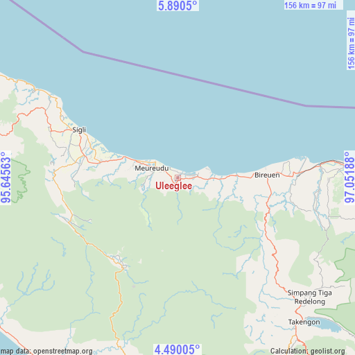
Uleeglee GPS coordinates[2]
5° 11' 26.376" North, 96° 20' 55.5" East
| Map corner | latitude | longitude |
|---|---|---|
| Upper-left | 5.8905°, | 95.64563° |
| Center: | 5.19066°, | 96.34875° |
| Lower-right: | 4.49005°, | 97.05188° |
| Map W x H: | 155.7×155.7 km | = 96.7×96.7mi |
| max Lat: | 5.88969° ⇑0.4% North |
| Uleeglee: | 5.19066° |
| min Lat: | ⇓99.6% South -10.934° |
| min Long | Uleeglee | max Long |
| 95.1345° | 96.34875° | 140.9419° |
| W 0.6%⇐ | ⇒99.4% E |
Elevation
Elevation of Uleeglee is 14 m = 46 ft, and this is 215.7 m = 708 ft below average elevation for this country.
| Max E: |
3185 m = 10449 ft | 85.2% |
| Avg. | 229.7 m = 754 ft | |
| Uleeglee | 14 m = 46 ft | |
Min E: |
-1 m = -3 ft | 14.8% |
See also: Indonesia elevation on elevation.city.
Geographical zone
Uleeglee is located in North Torrid zone (between Equator and Tropic of Cancer). Distance of Equator is 577.1 km =358.6 mi to South.| Distance of | km | miles | from Uleeglee |
|---|---|---|---|
| North Pole | 9429.9 | 5859.5 | to North |
| Arctic Circle | 6824 | 4240.2 | to North |
| Tropic Cancer | 2028.8 | 1260.6 | to North |
| Equator | 577.1 | 358.6 | to South |


Nearby cities:
15 places around Uleeglee: (largest is in red/bold)
• Asan Kumbang
37.8 km =23.5 mi,  289°
289°
• Bireun
39 km =24.2 mi,  87°
87°
• Caloue
44.1 km =27.4 mi, 288°
• Geuleumpangminyeuk
36 km =22.4 mi,  280°
280°
• Geumpang
45.3 km =28.1 mi,  207°
207°
• Juli
41.1 km =25.5 mi,  102°
102°
• Keumala
47.5 km =29.5 mi, 277°
• Lampoih
42.6 km =26.5 mi, 289°
• Lueng Putu
33.2 km =20.6 mi, 282°
• Mane
47.2 km =29.3 mi,  233°
233°
• Pante Raja
23.2 km =14.4 mi, 285°
• Reuleuet
7.8 km =4.8 mi, 291°
• Tiro
45.6 km =28.3 mi,  270°
270°
• Trienggadeng
17.2 km =10.7 mi, 288°
• Ulee Gle
2.8 km =1.7 mi,  299°
299°
Sources, notices
• [Note1] Compared only with cities in Indonesia existing in our database
• [Src1] Map data: © OpenStreetMap contributors (CC-BY-SA)
• [Src2] Other city data from geonames.org with taken over terms of usage.
• [Src3] Geographical zone / Annual Mean Temperature by Robert A. Rohde @ Wikipedia
