Ulee Gle geodata
Ulee Gle (Aceh) is a seat of a third-order administrative division; located in Indonesia in Asia/Jakarta (GMT+7) time zone. In our database, there are 407 cities with bigger population. Compared to other cities in Indonesia, 99.7% of cities are located further ↓South; 99.5% of cities are located further →East and 80.9% of cities have higher elevation than Ulee Gle. Note1


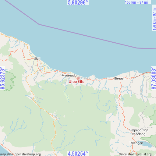
Ulee Gle GPS coordinates[2]
5° 12' 11.304" North, 96° 19' 36.84" East
| Map corner | latitude | longitude |
|---|---|---|
| Upper-left | 5.90296°, | 95.62378° |
| Center: | 5.20314°, | 96.3269° |
| Lower-right: | 4.50254°, | 97.03003° |
| Map W x H: | 155.7×155.7 km | = 96.7×96.7mi |
| max Lat: | 5.88969° ⇑0.3% North |
| Ulee Gle: | 5.20314° |
| min Lat: | ⇓99.7% South -10.934° |
| min Long | Ulee Gle | max Long |
| 95.1345° | 96.3269° | 140.9419° |
| W 0.5%⇐ | ⇒99.5% E |
Elevation
Elevation of Ulee Gle is 18 m = 59 ft, and this is 211.7 m = 695 ft below average elevation for this country.
| Max E: |
3185 m = 10449 ft | 80.9% |
| Avg. | 229.7 m = 754 ft | |
| Ulee Gle | 18 m = 59 ft | |
Min E: |
-1 m = -3 ft | 19.1% |
See also: Indonesia elevation on elevation.city.
Geographical zone
Ulee Gle is located in North Torrid zone (between Equator and Tropic of Cancer). Distance of Equator is 578.5 km =359.5 mi to South.| Distance of | km | miles | from Ulee Gle |
|---|---|---|---|
| North Pole | 9428.5 | 5858.6 | to North |
| Arctic Circle | 6822.6 | 4239.4 | to North |
| Tropic Cancer | 2027.4 | 1259.8 | to North |
| Equator | 578.5 | 359.5 | to South |


Nearby cities:
15 places around Ulee Gle: (largest is in red/bold)
• Asan Kumbang
35 km =21.7 mi,  288°
288°
• Bireun
41.4 km =25.7 mi,  90°
90°
• Caloue
41.4 km =25.7 mi, 287°
• Geuleumpangminyeuk
33.4 km =20.8 mi,  278°
278°
• Geumpang
45.5 km =28.3 mi,  203°
203°
• Juli
43.8 km =27.2 mi,  104°
104°
• Keumala
44.9 km =27.9 mi, 276°
• Lampoih
39.8 km =24.7 mi, 288°
• Lueng Putu
30.5 km =19 mi, 281°
• Pante Raja
20.5 km =12.7 mi, 283°
• Reuleuet
5.1 km =3.2 mi, 287°
• Sigli
45.3 km =28.1 mi,  296°
296°
• Tiro
43.2 km =26.8 mi,  268°
268°
• Trienggadeng
14.5 km =9 mi, 286°
• Uleeglee
2.8 km =1.7 mi,  119°
119°
Sources, notices
• [Note1] Compared only with cities in Indonesia existing in our database
• [Src1] Map data: © OpenStreetMap contributors (CC-BY-SA)
• [Src2] Other city data from geonames.org with taken over terms of usage.
• [Src3] Geographical zone / Annual Mean Temperature by Robert A. Rohde @ Wikipedia
