Gunung Tua geodata
Gunung Tua (North Sumatra) is a seat of a second-order administrative division; located in Indonesia in Asia/Jakarta (GMT+7) time zone. In our database, there are 407 cities with bigger population. Compared to other cities in Indonesia, 96.7% of cities are located further ↓South; 97.6% of cities are located further →East and 50.6% of cities have lower elevation than Gunung Tua. Note1


Gunung Tua GPS coordinates[2]
1° 30' 45.864" North, 99° 37' 34.608" East
| Map corner | latitude | longitude |
|---|---|---|
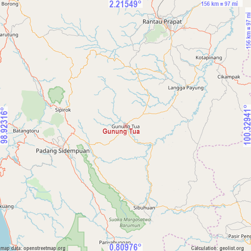
| Upper-left | 2.21549°, | 98.92316° |
| Center: | 1.51274°, | 99.62628° |
| Lower-right: | 0.80976°, | 100.32941° |
| Map W x H: | 156.3×156.3 km | = 97.1×97.1mi |
| max Lat: | 5.88969° ⇑3.3% North |
| Gunung Tua: | 1.51274° |
| min Lat: | ⇓96.7% South -10.934° |
| min Long | Gunung Tua | max Long |
| 95.1345° | 99.62628° | 140.9419° |
| W 2.4%⇐ | ⇒97.6% E |
Elevation
Elevation of Gunung Tua is 104 m = 341 ft, and this is 125.7 m = 412 ft below average elevation for this country.
| Max E: |
3185 m = 10449 ft | 49.4% |
| Avg. | 229.7 m = 754 ft | |
| Gunung Tua | 104 m = 341 ft | |
Min E: |
-1 m = -3 ft | 50.6% |
See also: Indonesia elevation on elevation.city.
Geographical zone
Gunung Tua is located in North Torrid zone (between Equator and Tropic of Cancer). Distance of Equator is 168.2 km =104.5 mi to South.| Distance of | km | miles | from Gunung Tua |
|---|---|---|---|
| North Pole | 9838.9 | 6113.6 | to North |
| Arctic Circle | 7233 | 4494.4 | to North |
| Tropic Cancer | 2437.7 | 1514.7 | to North |
| Equator | 168.2 | 104.5 | to South |


Nearby cities:
15 places around Gunung Tua: (largest is in red/bold)
• Bandar
61.3 km =38.1 mi,  12°
12°
• Batangtoru
62.4 km =38.8 mi,  266°
266°
• Binanga
20.2 km =12.6 mi,  124°
124°
• Langgapayung
44.3 km =27.5 mi,  57°
57°
• Padangsidempuan
42.1 km =26.2 mi,  249°
249°
• Panyabungan
47.2 km =29.3 mi, 8°
• Pasarujungbatu
64 km =39.8 mi,  145°
145°
• Pintupadang
43.5 km =27 mi,  225°
225°
• Sarulla
64.6 km =40.1 mi,  298°
298°
• Siabu
57.2 km =35.5 mi,  194°
194°
• Sibuhuan
52.3 km =32.5 mi,  167°
167°
• Sipagimbar
45.3 km =28.1 mi,  321°
321°
• Sipiongot
36.1 km =22.4 mi, 6°
• Sipirok
40.4 km =25.1 mi,  284°
284°
• Ujungbatu
62.5 km =38.8 mi, 146°
Sources, notices
• [Note1] Compared only with cities in Indonesia existing in our database
• [Src1] Map data: © OpenStreetMap contributors (CC-BY-SA)
• [Src2] Other city data from geonames.org with taken over terms of usage.
• [Src3] Geographical zone / Annual Mean Temperature by Robert A. Rohde @ Wikipedia
