Sipiongot geodata
Sipiongot (North Sumatra) is a seat of a third-order administrative division; located in Indonesia in Asia/Jakarta (GMT+7) time zone. In our database, there are 407 cities with bigger population. Compared to other cities in Indonesia, 97% of cities are located further ↓South; 97.6% of cities are located further →East and 54.7% of cities have lower elevation than Sipiongot. Note1


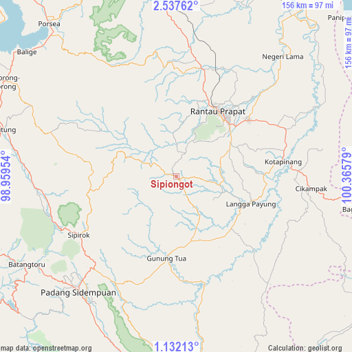
Sipiongot GPS coordinates[2]
1° 50' 6.036" North, 99° 39' 45.576" East
| Map corner | latitude | longitude |
|---|---|---|
| Upper-left | 2.53762°, | 98.95954° |
| Center: | 1.83501°, | 99.66266° |
| Lower-right: | 1.13213°, | 100.36579° |
| Map W x H: | 156.3×156.3 km | = 97.1×97.1mi |
| max Lat: | 5.88969° ⇑3% North |
| Sipiongot: | 1.83501° |
| min Lat: | ⇓97% South -10.934° |
| min Long | Sipiongot | max Long |
| 95.1345° | 99.66266° | 140.9419° |
| W 2.4%⇐ | ⇒97.6% E |
Elevation
Elevation of Sipiongot is 123 m = 404 ft, and this is 106.7 m = 350 ft below average elevation for this country.
| Max E: |
3185 m = 10449 ft | 45.3% |
| Avg. | 229.7 m = 754 ft | |
| Sipiongot | 123 m = 404 ft | |
Min E: |
-1 m = -3 ft | 54.7% |
See also: Indonesia elevation on elevation.city.
Geographical zone
Sipiongot is located in North Torrid zone (between Equator and Tropic of Cancer). Distance of Equator is 204 km =126.8 mi to South.| Distance of | km | miles | from Sipiongot |
|---|---|---|---|
| North Pole | 9803 | 6091.3 | to North |
| Arctic Circle | 7197.1 | 4472.1 | to North |
| Tropic Cancer | 2401.9 | 1492.5 | to North |
| Equator | 204 | 126.8 | to South |


Nearby cities:
15 places around Sipiongot: (largest is in red/bold)
• Bandar
25.8 km =16 mi,  22°
22°
• Batangtoru
77.1 km =47.9 mi,  239°
239°
• Binanga
48.9 km =30.4 mi,  165°
165°
• Gunung Tua
36.1 km =22.4 mi,  186°
186°
• Kota Pinang
48.1 km =29.9 mi,  82°
82°
• Langgapayung
35.5 km =22.1 mi,  109°
109°
• Padangsidempuan
66.7 km =41.4 mi,  220°
220°
• Panyabungan
11.2 km =7 mi, 16°
• Pintupadang
75 km =46.6 mi,  208°
208°
• Rantau Prapat
70.2 km =43.6 mi,  38°
38°
• Rantauprapat
35 km =21.7 mi,  32°
32°
• Sampuran
79.7 km =49.5 mi,  284°
284°
• Sarulla
61.2 km =38 mi,  264°
264°
• Sipagimbar
32.3 km =20.1 mi,  269°
269°
• Sipirok
50.4 km =31.3 mi, 239°
Sources, notices
• [Note1] Compared only with cities in Indonesia existing in our database
• [Src1] Map data: © OpenStreetMap contributors (CC-BY-SA)
• [Src2] Other city data from geonames.org with taken over terms of usage.
• [Src3] Geographical zone / Annual Mean Temperature by Robert A. Rohde @ Wikipedia
