Long Loreh geodata
Long Loreh (North Kalimantan) is a seat of a third-order administrative division; located in Indonesia in Asia/Makassar (GMT+8) time zone. In our database, there are 407 cities with bigger population. Compared to other cities in Indonesia, 98.1% of cities are located further ↓South; 77.4% of cities are located further ←West and 60.6% of cities have higher elevation than Long Loreh. Note1


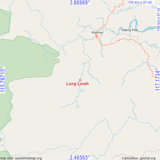
Long Loreh GPS coordinates[2]
3° 10' 4.44" North, 116° 28' 12.972" East
| Map corner | latitude | longitude |
|---|---|---|
| Upper-left | 3.86969°, | 115.76715° |
| Center: | 3.1679°, | 116.47027° |
| Lower-right: | 2.46563°, | 117.1734° |
| Map W x H: | 156.1×156.1 km | = 97×97mi |
| max Lat: | 5.88969° ⇑1.9% North |
| Long Loreh: | 3.1679° |
| min Lat: | ⇓98.1% South -10.934° |
| min Long | Long Loreh | max Long |
| 95.1345° | 116.47027° | 140.9419° |
| W 77.4%⇐ | ⇒22.6% E |
Elevation
Elevation of Long Loreh is 57 m = 187 ft, and this is 172.7 m = 567 ft below average elevation for this country.
| Max E: |
3185 m = 10449 ft | 60.6% |
| Avg. | 229.7 m = 754 ft | |
| Long Loreh | 57 m = 187 ft | |
Min E: |
-1 m = -3 ft | 39.4% |
See also: Indonesia elevation on elevation.city.
Geographical zone
Long Loreh is located in North Torrid zone (between Equator and Tropic of Cancer). Distance of Equator is 352.2 km =218.8 mi to South.| Distance of | km | miles | from Long Loreh |
|---|---|---|---|
| North Pole | 9654.8 | 5999.2 | to North |
| Arctic Circle | 7048.9 | 4380 | to North |
| Tropic Cancer | 2253.7 | 1400.4 | to North |
| Equator | 352.2 | 218.8 | to South |


Nearby cities:
15 places around Long Loreh: (largest is in red/bold)
• Atap
99.8 km =62 mi,  39°
39°
• Kayan Hulu
99.2 km =61.6 mi,  317°
317°
• Kerangagung
85 km =52.8 mi,  102°
102°
• Long Bang
59.9 km =37.2 mi,  126°
126°
• Long Beluah
82.3 km =51.1 mi,  123°
123°
• Long Layu
98.6 km =61.3 mi,  299°
299°
• Long Peso
63.6 km =39.5 mi,  146°
146°
• Long Pujungan
98.9 km =61.5 mi,  229°
229°
• Malinau
49.8 km =30.9 mi,  20°
20°
• Mensalong
72.5 km =45 mi, 24°
• Mentarang
59.2 km =36.8 mi,  325°
325°
• Salinbatu
100.2 km =62.3 mi, 104°
• Sekatak Bengara
83 km =51.6 mi, 96°
• Sesayap
75.6 km =47 mi,  52°
52°
• Tideng Pale
68.9 km =42.8 mi, 44°
Sources, notices
• [Note1] Compared only with cities in Indonesia existing in our database
• [Src1] Map data: © OpenStreetMap contributors (CC-BY-SA)
• [Src2] Other city data from geonames.org with taken over terms of usage.
• [Src3] Geographical zone / Annual Mean Temperature by Robert A. Rohde @ Wikipedia
