Sekatak Bengara geodata
Sekatak Bengara (North Kalimantan) is a seat of a third-order administrative division; located in Indonesia in Asia/Makassar (GMT+8) time zone. In our database, there are 407 cities with bigger population. Compared to other cities in Indonesia, 98.1% of cities are located further ↓South; 78.7% of cities are located further ←West and 79.9% of cities have higher elevation than Sekatak Bengara. Note1


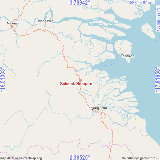
Sekatak Bengara GPS coordinates[2]
3° 5' 15.252" North, 117° 12' 48.42" East
| Map corner | latitude | longitude |
|---|---|---|
| Upper-left | 3.78942°, | 116.51033° |
| Center: | 3.08757°, | 117.21345° |
| Lower-right: | 2.38525°, | 117.91658° |
| Map W x H: | 156.1×156.1 km | = 97×97mi |
| max Lat: | 5.88969° ⇑1.9% North |
| Sekatak Bengara: | 3.08757° |
| min Lat: | ⇓98.1% South -10.934° |
| min Long | Sekatak Bengara | max Long |
| 95.1345° | 117.21345° | 140.9419° |
| W 78.7%⇐ | ⇒21.3% E |
Elevation
Elevation of Sekatak Bengara is 19 m = 62 ft, and this is 210.7 m = 691 ft below average elevation for this country.
| Max E: |
3185 m = 10449 ft | 79.9% |
| Avg. | 229.7 m = 754 ft | |
| Sekatak Bengara | 19 m = 62 ft | |
Min E: |
-1 m = -3 ft | 20.1% |
See also: Indonesia elevation on elevation.city.
Geographical zone
Sekatak Bengara is located in North Torrid zone (between Equator and Tropic of Cancer). Distance of Equator is 343.3 km =213.3 mi to South.| Distance of | km | miles | from Sekatak Bengara |
|---|---|---|---|
| North Pole | 9663.8 | 6004.8 | to North |
| Arctic Circle | 7057.9 | 4385.6 | to North |
| Tropic Cancer | 2262.6 | 1405.9 | to North |
| Equator | 343.3 | 213.3 | to South |


Nearby cities:
15 places around Sekatak Bengara: (largest is in red/bold)
• Atap
87.6 km =54.4 mi,  347°
347°
• Kerangagung
9.6 km =6 mi,  177°
177°
• Long Bang
43.4 km =27 mi,  232°
232°
• Long Beluah
39 km =24.2 mi,  200°
200°
• Long Loreh
83 km =51.6 mi,  276°
276°
• Long Peso
64.9 km =40.3 mi, 227°
• Malinau
85.9 km =53.4 mi,  310°
310°
• Mensalong
90.9 km =56.5 mi,  325°
325°
• Salinbatu
21.8 km =13.5 mi,  138°
138°
• Sebuku
103.6 km =64.4 mi, 348°
• Sesayap
59.9 km =37.2 mi,  337°
337°
• Tanjung Palas
32 km =19.9 mi,  153°
153°
• Tanjung Selor
32.5 km =20.2 mi, 148°
• Tarakan
48.9 km =30.4 mi,  59°
59°
• Tideng Pale
67.2 km =41.8 mi, 329°
Sources, notices
• [Note1] Compared only with cities in Indonesia existing in our database
• [Src1] Map data: © OpenStreetMap contributors (CC-BY-SA)
• [Src2] Other city data from geonames.org with taken over terms of usage.
• [Src3] Geographical zone / Annual Mean Temperature by Robert A. Rohde @ Wikipedia
