Stabat geodata
Stabat (North Sumatra) is a populated place; located in Indonesia in Asia/Jakarta (GMT+7) time zone. With population of 26,862 people, there are 340 cities with bigger population in this country. Compared to other cities in Indonesia, 98.6% of cities are located further ↓South; 98.3% of cities are located further →East and 87.7% of cities have higher elevation than Stabat. Note1


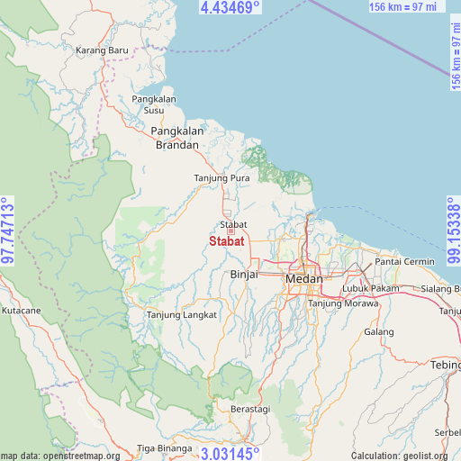
Stabat GPS coordinates[2]
3° 44' 0.06" North, 98° 27' 0.9" East
| Map corner | latitude | longitude |
|---|---|---|
| Upper-left | 4.43469°, | 97.74713° |
| Center: | 3.73335°, | 98.45025° |
| Lower-right: | 3.03145°, | 99.15338° |
| Map W x H: | 156×156 km | = 96.9×96.9mi |
| max Lat: | 5.88969° ⇑1.4% North |
| Stabat: | 3.73335° |
| min Lat: | ⇓98.6% South -10.934° |
| min Long | Stabat | max Long |
| 95.1345° | 98.45025° | 140.9419° |
| W 1.7%⇐ | ⇒98.3% E |
Elevation
Elevation of Stabat is 12 m = 39 ft, and this is 217.7 m = 714 ft below average elevation for this country.
| Max E: |
3185 m = 10449 ft | 87.7% |
| Avg. | 229.7 m = 754 ft | |
| Stabat | 12 m = 39 ft | |
Min E: |
-1 m = -3 ft | 12.3% |
See also: Indonesia elevation on elevation.city.
Geographical zone
Stabat is located in North Torrid zone (between Equator and Tropic of Cancer). Distance of Equator is 415.1 km =257.9 mi to South.| Distance of | km | miles | from Stabat |
|---|---|---|---|
| North Pole | 9592 | 5960.2 | to North |
| Arctic Circle | 6986.1 | 4341 | to North |
| Tropic Cancer | 2190.8 | 1361.3 | to North |
| Equator | 415.1 | 257.9 | to South |


Nearby cities:
15 places around Stabat: (largest is in red/bold)
• Bambol
70.7 km =43.9 mi,  243°
243°
• Belawan
26.3 km =16.3 mi,  79°
79°
• Berastagi
60.2 km =37.4 mi,  173°
173°
• Binjai
15.3 km =9.5 mi, 165°
• Deli Tua
36.1 km =22.4 mi,  134°
134°
• Kabanjahe
70.6 km =43.9 mi,  176°
176°
• Labuhan Deli
24.8 km =15.4 mi,  91°
91°
• Lubuk Pakam
50.8 km =31.6 mi,  112°
112°
• Medan
29.2 km =18.1 mi,  124°
124°
• Pangkalan Brandan
37.5 km =23.3 mi,  329°
329°
• Perbaungan
59.1 km =36.7 mi, 108°
• Percut
47.5 km =29.5 mi,  104°
104°
• Sunggal
25.3 km =15.7 mi, 133°
• Tanjungtiram
37.5 km =23.3 mi,  346°
346°
• Tenggulun
56.9 km =35.4 mi,  300°
300°
Sources, notices
• [Note1] Compared only with cities in Indonesia existing in our database
• [Src1] Map data: © OpenStreetMap contributors (CC-BY-SA)
• [Src2] Other city data from geonames.org with taken over terms of usage.
• [Src3] Geographical zone / Annual Mean Temperature by Robert A. Rohde @ Wikipedia
