Sunggal geodata
Sunggal (North Sumatra) is a populated place; located in Indonesia in Asia/Jakarta (GMT+7) time zone. With population of 157,914 people, there are 71 cities with bigger population in this country. Compared to other cities in Indonesia, 98.4% of cities are located further ↓South; 98.2% of cities are located further →East and 70.2% of cities have higher elevation than Sunggal. Note1


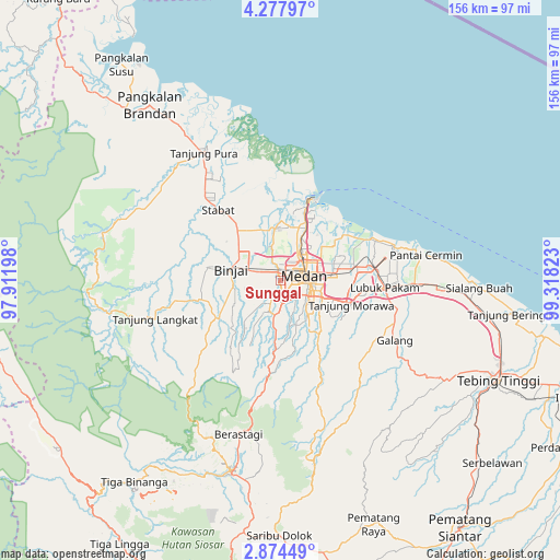
Sunggal GPS coordinates[2]
3° 34' 35.4" North, 98° 36' 54.36" East
| Map corner | latitude | longitude |
|---|---|---|
| Upper-left | 4.27797°, | 97.91198° |
| Center: | 3.5765°, | 98.6151° |
| Lower-right: | 2.87449°, | 99.31823° |
| Map W x H: | 156.1×156.1 km | = 97×97mi |
| max Lat: | 5.88969° ⇑1.6% North |
| Sunggal: | 3.5765° |
| min Lat: | ⇓98.4% South -10.934° |
| min Long | Sunggal | max Long |
| 95.1345° | 98.6151° | 140.9419° |
| W 1.8%⇐ | ⇒98.2% E |
Elevation
Elevation of Sunggal is 32 m = 105 ft, and this is 197.7 m = 649 ft below average elevation for this country.
| Max E: |
3185 m = 10449 ft | 70.2% |
| Avg. | 229.7 m = 754 ft | |
| Sunggal | 32 m = 105 ft | |
Min E: |
-1 m = -3 ft | 29.8% |
See also: Sunggal elevation on elevation.city.
Geographical zone
Sunggal is located in North Torrid zone (between Equator and Tropic of Cancer). Distance of Equator is 397.7 km =247.1 mi to South.| Distance of | km | miles | from Sunggal |
|---|---|---|---|
| North Pole | 9609.4 | 5971 | to North |
| Arctic Circle | 7003.5 | 4351.8 | to North |
| Tropic Cancer | 2208.2 | 1372.1 | to North |
| Equator | 397.7 | 247.1 | to South |


Nearby cities:
15 places around Sunggal: (largest is in red/bold)
• Belawan
23.4 km =14.5 mi,  18°
18°
• Berastagi
44.1 km =27.4 mi,  195°
195°
• Binjai
14.6 km =9.1 mi,  280°
280°
• Deli Tua
10.8 km =6.7 mi,  135°
135°
• Kabanjahe
54.7 km =34 mi,  194°
194°
• Labuhan Deli
18 km =11.2 mi, 21°
• Lubuk Pakam
28.7 km =17.8 mi,  93°
93°
• Medan
5.8 km =3.6 mi,  82°
82°
• Pangkalan Brandan
62.2 km =38.6 mi,  323°
323°
• Perbaungan
37.8 km =23.5 mi, 91°
• Percut
28.1 km =17.5 mi, 78°
• Sei Rampah
58.8 km =36.5 mi,  100°
100°
• Stabat
25.3 km =15.7 mi,  313°
313°
• Tanjungtiram
60.4 km =37.5 mi,  333°
333°
• Tebingtinggi
66.7 km =41.4 mi,  114°
114°
Sources, notices
• [Note1] Compared only with cities in Indonesia existing in our database
• [Src1] Map data: © OpenStreetMap contributors (CC-BY-SA)
• [Src2] Other city data from geonames.org with taken over terms of usage.
• [Src3] Geographical zone / Annual Mean Temperature by Robert A. Rohde @ Wikipedia
