Wotu geodata
Wotu (South Sulawesi) is a seat of a third-order administrative division; located in Indonesia in Asia/Makassar (GMT+8) time zone. In our database, there are 407 cities with bigger population. Compared to other cities in Indonesia, 92% of cities are located further ↓South; 85.2% of cities are located further ←West and 93.7% of cities have higher elevation than Wotu. Note1


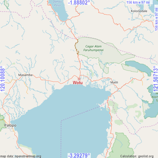
Wotu GPS coordinates[2]
2° 35' 26.16" South, 120° 48' 14.4" East
| Map corner | latitude | longitude |
|---|---|---|
| Upper-left | -1.88802°, | 120.10088° |
| Center: | -2.5906°, | 120.804° |
| Lower-right: | -3.29279°, | 121.50713° |
| Map W x H: | 156.2×156.2 km | = 97.1×97.1mi |
| max Lat: | 5.88969° ⇑8% North |
| Wotu: | -2.5906° |
| min Lat: | ⇓92% South -10.934° |
| min Long | Wotu | max Long |
| 95.1345° | 120.804° | 140.9419° |
| W 85.2%⇐ | ⇒14.8% E |
Elevation
Elevation of Wotu is 8 m = 26 ft, and this is 221.7 m = 727 ft below average elevation for this country.
| Max E: |
3185 m = 10449 ft | 93.7% |
| Avg. | 229.7 m = 754 ft | |
| Wotu | 8 m = 26 ft | |
Min E: |
-1 m = -3 ft | 6.3% |
See also: Indonesia elevation on elevation.city.
Geographical zone
Wotu is located in South Torrid zone (between Equator and Tropic of Capricorn). Distance of Equator is 288 km =179 mi to North.| Distance of | km | miles | from Wotu |
|---|---|---|---|
| Equator | 288 | 179 | to North |
| Tropic Capricorn | 2317.9 | 1440.3 | to South |
| Antarctic Circle | 7113.1 | 4419.9 | to South |
| South Pole | 9719 | 6039.1 | to South |


Nearby cities:
15 places around Wotu: (largest is in red/bold)
• Batuputih
80.4 km =50 mi,  239°
239°
• Beringinjaya
81 km =50.3 mi, 235°
• Bonebone
31.6 km =19.6 mi,  268°
268°
• Kolonodale
89.8 km =55.8 mi,  41°
41°
• Lamasi
74.1 km =46 mi,  250°
250°
• Malili
32.7 km =20.3 mi,  98°
98°
• Mangkutana
11.3 km =7 mi,  4°
4°
• Masamba
53 km =32.9 mi, 274°
• Padangsappa
90.9 km =56.5 mi,  217°
217°
• Palopo
80.9 km =50.3 mi, 236°
• Pendolo
58.9 km =36.6 mi,  347°
347°
• Sukamaju
37.6 km =23.4 mi, 266°
• Tentena
94.4 km =58.7 mi, 349°
• Walenrang
80.7 km =50.1 mi, 249°
• Wonorejo
10.8 km =6.7 mi,  5°
5°
Sources, notices
• [Note1] Compared only with cities in Indonesia existing in our database
• [Src1] Map data: © OpenStreetMap contributors (CC-BY-SA)
• [Src2] Other city data from geonames.org with taken over terms of usage.
• [Src3] Geographical zone / Annual Mean Temperature by Robert A. Rohde @ Wikipedia
