Sukamaju geodata
Sukamaju (South Sulawesi) is a seat of a third-order administrative division; located in Indonesia in Asia/Makassar (GMT+8) time zone. In our database, there are 407 cities with bigger population. Compared to other cities in Indonesia, 92% of cities are located further ↓South; 84.2% of cities are located further ←West and 71.9% of cities have higher elevation than Sukamaju. Note1


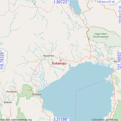
Sukamaju GPS coordinates[2]
2° 36' 35.28" South, 120° 27' 59.04" East
| Map corner | latitude | longitude |
|---|---|---|
| Upper-left | -1.90723°, | 119.76328° |
| Center: | -2.6098°, | 120.4664° |
| Lower-right: | -3.31198°, | 121.16953° |
| Map W x H: | 156.2×156.2 km | = 97.1×97.1mi |
| max Lat: | 5.88969° ⇑8% North |
| Sukamaju: | -2.6098° |
| min Lat: | ⇓92% South -10.934° |
| min Long | Sukamaju | max Long |
| 95.1345° | 120.4664° | 140.9419° |
| W 84.2%⇐ | ⇒15.8% E |
Elevation
Elevation of Sukamaju is 29 m = 95 ft, and this is 200.7 m = 658 ft below average elevation for this country.
| Max E: |
3185 m = 10449 ft | 71.9% |
| Avg. | 229.7 m = 754 ft | |
| Sukamaju | 29 m = 95 ft | |
Min E: |
-1 m = -3 ft | 28.1% |
See also: Indonesia elevation on elevation.city.
Geographical zone
Sukamaju is located in South Torrid zone (between Equator and Tropic of Capricorn). Distance of Equator is 290.2 km =180.3 mi to North.| Distance of | km | miles | from Sukamaju |
|---|---|---|---|
| Equator | 290.2 | 180.3 | to North |
| Tropic Capricorn | 2315.7 | 1438.9 | to South |
| Antarctic Circle | 7111 | 4418.6 | to South |
| South Pole | 9716.9 | 6037.8 | to South |


Nearby cities:
15 places around Sukamaju: (largest is in red/bold)
• Batuputih
50.1 km =31.1 mi,  219°
219°
• Beringinjaya
52.8 km =32.8 mi,  213°
213°
• Bonebone
6 km =3.7 mi,  80°
80°
• Lamasi
39.6 km =24.6 mi,  234°
234°
• Malili
69.9 km =43.4 mi,  92°
92°
• Mangkutana
40.7 km =25.3 mi,  70°
70°
• Masamba
16.6 km =10.3 mi,  292°
292°
• Padangsappa
71.9 km =44.7 mi,  194°
194°
• Palopo
52 km =32.3 mi, 215°
• Pendolo
64.3 km =40 mi,  22°
22°
• Rantepang
68 km =42.3 mi,  238°
238°
• Rantepao
74.8 km =46.5 mi, 237°
• Walenrang
46.1 km =28.6 mi, 236°
• Wonorejo
40.6 km =25.2 mi, 71°
• Wotu
37.6 km =23.4 mi, 86°
Sources, notices
• [Note1] Compared only with cities in Indonesia existing in our database
• [Src1] Map data: © OpenStreetMap contributors (CC-BY-SA)
• [Src2] Other city data from geonames.org with taken over terms of usage.
• [Src3] Geographical zone / Annual Mean Temperature by Robert A. Rohde @ Wikipedia
