Welahan geodata
Welahan (Central Java) is a populated place; located in Indonesia in Asia/Jakarta (GMT+7) time zone. With population of 26,163 people, there are 347 cities with bigger population in this country. Compared to other cities in Indonesia, 76.4% of cities are located further ↓South; 65.2% of cities are located further →East and 99.1% of cities have higher elevation than Welahan. Note1


Welahan GPS coordinates[2]
6° 48' 0" South, 110° 43' 0.012" East
| Map corner | latitude | longitude |
|---|---|---|
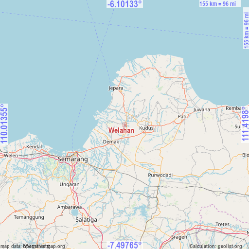
| Upper-left | -6.10133°, | 110.01355° |
| Center: | -6.8°, | 110.71667° |
| Lower-right: | -7.49765°, | 111.4198° |
| Map W x H: | 155.3×155.3 km | = 96.5×96.5mi |
| max Lat: | 5.88969° ⇑23.6% North |
| Welahan: | -6.8° |
| min Lat: | ⇓76.4% South -10.934° |
| min Long | Welahan | max Long |
| 95.1345° | 110.71667° | 140.9419° |
| W 34.8%⇐ | ⇒65.2% E |
Elevation
Elevation of Welahan is 4 m = 13 ft, and this is 225.7 m = 740 ft below average elevation for this country.
| Max E: |
3185 m = 10449 ft | 99.1% |
| Avg. | 229.7 m = 754 ft | |
| Welahan | 4 m = 13 ft | |
Min E: |
-1 m = -3 ft | 0.9% |
See also: Indonesia elevation on elevation.city.
Geographical zone
Welahan is located in South Torrid zone (between Equator and Tropic of Capricorn). Distance of Equator is 756.1 km =469.8 mi to North.| Distance of | km | miles | from Welahan |
|---|---|---|---|
| Equator | 756.1 | 469.8 | to North |
| Tropic Capricorn | 1849.8 | 1149.4 | to South |
| Antarctic Circle | 6645.1 | 4129.1 | to South |
| South Pole | 9251 | 5748.3 | to South |


Nearby cities:
15 places around Welahan: (largest is in red/bold)
• Baekrajan
15.6 km =9.7 mi,  76°
76°
• Demak
13.2 km =8.2 mi,  220°
220°
• Gebog
15.8 km =9.8 mi,  62°
62°
• Gemiring
33.4 km =20.8 mi, 81°
• Jekulo
23.1 km =14.4 mi,  91°
91°
• Jepara
23.6 km =14.7 mi,  347°
347°
• Kudus
13.7 km =8.5 mi, 92°
• Mlonggo
29.7 km =18.5 mi,  356°
356°
• Mranggen
33.6 km =20.9 mi, 221°
• Pecangaan
11.4 km =7.1 mi, 356°
• Purwosari
33.3 km =20.7 mi,  70°
70°
• Randangan
31.8 km =19.8 mi, 71°
• Rendole
33.4 km =20.8 mi, 77°
• Tlogorejo
34.6 km =21.5 mi, 73°
• Tlogowungu
34.4 km =21.4 mi, 72°
Sources, notices
• [Note1] Compared only with cities in Indonesia existing in our database
• [Src1] Map data: © OpenStreetMap contributors (CC-BY-SA)
• [Src2] Other city data from geonames.org with taken over terms of usage.
• [Src3] Geographical zone / Annual Mean Temperature by Robert A. Rohde @ Wikipedia
