Purworejo geodata
Purworejo (Central Java) is a seat of a second-order administrative division; located in Indonesia in Asia/Jakarta (GMT+7) time zone. In our database, there are 407 cities with bigger population. Compared to other cities in Indonesia, 59.8% of cities are located further ↑North; 65.7% of cities are located further →East and 57.2% of cities have higher elevation than Purworejo. Note1


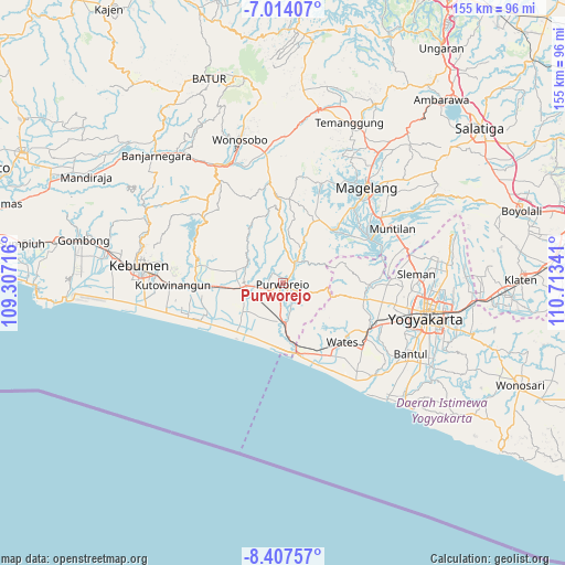
Purworejo GPS coordinates[2]
7° 42' 41.004" South, 110° 0' 37.008" East
| Map corner | latitude | longitude |
|---|---|---|
| Upper-left | -7.01407°, | 109.30716° |
| Center: | -7.71139°, | 110.01028° |
| Lower-right: | -8.40757°, | 110.71341° |
| Map W x H: | 154.9×154.9 km | = 96.3×96.3mi |
| max Lat: | 5.88969° ⇑59.8% North |
| Purworejo: | -7.71139° |
| min Lat: | ⇓40.2% South -10.934° |
| min Long | Purworejo | max Long |
| 95.1345° | 110.01028° | 140.9419° |
| W 34.3%⇐ | ⇒65.7% E |
Elevation
Elevation of Purworejo is 71 m = 233 ft, and this is 158.7 m = 521 ft below average elevation for this country.
| Max E: |
3185 m = 10449 ft | 57.2% |
| Avg. | 229.7 m = 754 ft | |
| Purworejo | 71 m = 233 ft | |
Min E: |
-1 m = -3 ft | 42.8% |
See also: Indonesia elevation on elevation.city.
Geographical zone
Purworejo is located in South Torrid zone (between Equator and Tropic of Capricorn). Distance of Equator is 857.4 km =532.8 mi to North.| Distance of | km | miles | from Purworejo |
|---|---|---|---|
| Equator | 857.4 | 532.8 | to North |
| Tropic Capricorn | 1748.5 | 1086.5 | to South |
| Antarctic Circle | 6543.7 | 4066.1 | to South |
| South Pole | 9149.6 | 5685.3 | to South |


Nearby cities:
15 places around Purworejo: (largest is in red/bold)
• Bambanglipuro
40.1 km =24.9 mi,  131°
131°
• Gamping Lor
36.1 km =22.4 mi,  105°
105°
• Godean
31.9 km =19.8 mi,  101°
101°
• Kasihan
37.4 km =23.2 mi, 110°
• Kebumen
39.6 km =24.6 mi,  276°
276°
• Kutoarjo
10.8 km =6.7 mi,  266°
266°
• Magelang
35.2 km =21.9 mi,  40°
40°
• Melati
39.3 km =24.4 mi,  93°
93°
• Mertoyudan
31.9 km =19.8 mi,  48°
48°
• Mungkid
26.5 km =16.5 mi,  60°
60°
• Muntilan
34.3 km =21.3 mi,  65°
65°
• Pandak
38.4 km =23.9 mi, 125°
• Sleman
38 km =23.6 mi, 90°
• Srandakan
36.6 km =22.7 mi, 133°
• Wates
22.9 km =14.2 mi,  135°
135°
Sources, notices
• [Note1] Compared only with cities in Indonesia existing in our database
• [Src1] Map data: © OpenStreetMap contributors (CC-BY-SA)
• [Src2] Other city data from geonames.org with taken over terms of usage.
• [Src3] Geographical zone / Annual Mean Temperature by Robert A. Rohde @ Wikipedia
