Urung geodata
Urung (Riau Islands) is a seat of a fourth-order administrative division; located in Indonesia in Asia/Jakarta (GMT+7) time zone. In our database, there are 407 cities with bigger population. Compared to other cities in Indonesia, 95.9% of cities are located further ↓South; 95.4% of cities are located further →East and 84.2% of cities have higher elevation than Urung. Note1


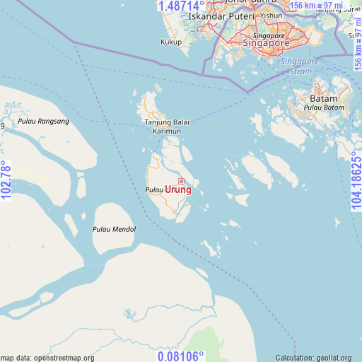
Urung GPS coordinates[2]
0° 47' 2.976" North, 103° 28' 59.232" East
| Map corner | latitude | longitude |
|---|---|---|
| Upper-left | 1.48714°, | 102.78° |
| Center: | 0.78416°, | 103.48312° |
| Lower-right: | 0.08106°, | 104.18625° |
| Map W x H: | 156.3×156.3 km | = 97.1×97.1mi |
| max Lat: | 5.88969° ⇑4.1% North |
| Urung: | 0.78416° |
| min Lat: | ⇓95.9% South -10.934° |
| min Long | Urung | max Long |
| 95.1345° | 103.48312° | 140.9419° |
| W 4.6%⇐ | ⇒95.4% E |
Elevation
Elevation of Urung is 15 m = 49 ft, and this is 214.7 m = 704 ft below average elevation for this country.
| Max E: |
3185 m = 10449 ft | 84.2% |
| Avg. | 229.7 m = 754 ft | |
| Urung | 15 m = 49 ft | |
Min E: |
-1 m = -3 ft | 15.8% |
See also: Indonesia elevation on elevation.city.
Geographical zone
Urung is located in North Torrid zone (between Equator and Tropic of Cancer). Distance of Equator is 87.2 km =54.2 mi to South.| Distance of | km | miles | from Urung |
|---|---|---|---|
| North Pole | 9919.9 | 6163.9 | to North |
| Arctic Circle | 7314 | 4544.7 | to North |
| Tropic Cancer | 2518.7 | 1565 | to North |
| Equator | 87.2 | 54.2 | to South |


Nearby cities:
15 places around Urung: (largest is in red/bold)
• Batam
72.6 km =45.1 mi,  56°
56°
• Belakangpadang
60.9 km =37.8 mi,  48°
48°
• Khairiahmandah
84.9 km =52.8 mi,  178°
178°
• Meral
25.5 km =15.8 mi,  336°
336°
• Moro
25.3 km =15.7 mi,  97°
97°
• Pancur Biru Lestari II
69.3 km =43.1 mi,  66°
66°
• Pasirpanjang
40.8 km =25.4 mi, 338°
• Sawang
15 km =9.3 mi,  249°
249°
• Sekupang
62.3 km =38.7 mi, 52°
• Selat Panjang
89.3 km =55.5 mi,  285°
285°
• Tanjung Pinang
109.4 km =68 mi,  82°
82°
• Tanjungbatu
14.1 km =8.8 mi,  189°
189°
• Tebing
28.4 km =17.6 mi,  345°
345°
• Teluk Pinang
108.3 km =67.3 mi, 187°
• Telukdalam
36.9 km =22.9 mi,  220°
220°
Sources, notices
• [Note1] Compared only with cities in Indonesia existing in our database
• [Src1] Map data: © OpenStreetMap contributors (CC-BY-SA)
• [Src2] Other city data from geonames.org with taken over terms of usage.
• [Src3] Geographical zone / Annual Mean Temperature by Robert A. Rohde @ Wikipedia
