Batam geodata
Batam (Riau) is a populated place; located in Indonesia in Asia/Jakarta (GMT+7) time zone. With population of 1,164,352 people, there are 11 cities with bigger population in this country. Compared to other cities in Indonesia, 96.4% of cities are located further ↓South; 95.1% of cities are located further →East and 66.8% of cities have higher elevation than Batam. Note1


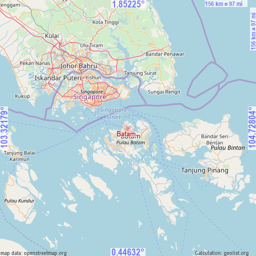
Batam GPS coordinates[2]
1° 8' 57.732" North, 104° 1' 29.676" East
| Map corner | latitude | longitude |
|---|---|---|
| Upper-left | 1.85225°, | 103.32179° |
| Center: | 1.14937°, | 104.02491° |
| Lower-right: | 0.44632°, | 104.72804° |
| Map W x H: | 156.3×156.3 km | = 97.1×97.1mi |
| max Lat: | 5.88969° ⇑3.6% North |
| Batam: | 1.14937° |
| min Lat: | ⇓96.4% South -10.934° |
| min Long | Batam | max Long |
| 95.1345° | 104.02491° | 140.9419° |
| W 4.9%⇐ | ⇒95.1% E |
Elevation
Elevation of Batam is 38 m = 125 ft, and this is 191.7 m = 629 ft below average elevation for this country.
| Max E: |
3185 m = 10449 ft | 66.8% |
| Avg. | 229.7 m = 754 ft | |
| Batam | 38 m = 125 ft | |
Min E: |
-1 m = -3 ft | 33.2% |
See also: Batam elevation on elevation.city.
Geographical zone
Batam is located in North Torrid zone (between Equator and Tropic of Cancer). Distance of Equator is 127.8 km =79.4 mi to South.| Distance of | km | miles | from Batam |
|---|---|---|---|
| North Pole | 9879.3 | 6138.7 | to North |
| Arctic Circle | 7273.4 | 4519.5 | to North |
| Tropic Cancer | 2478.1 | 1539.8 | to North |
| Equator | 127.8 | 79.4 | to South |


Nearby cities:
15 places around Batam: (largest is in red/bold)
• Bandar Seri Bentan
51.7 km =32.1 mi,  101°
101°
• Belakangpadang
14.8 km =9.2 mi,  270°
270°
• Khairiahmandah
138.5 km =86.1 mi,  205°
205°
• Kijang
73.1 km =45.4 mi,  112°
112°
• Meral
72.2 km =44.9 mi,  256°
256°
• Moro
56.3 km =35 mi,  218°
218°
• Pancur Biru Lestari II
13.6 km =8.5 mi,  165°
165°
• Pasirpanjang
75.1 km =46.7 mi, 268°
• Sawang
87.3 km =54.2 mi,  238°
238°
• Sekupang
11.2 km =7 mi, 257°
• Tanjung Pinang
54.7 km =34 mi,  118°
118°
• Tanjungbatu
83 km =51.6 mi,  228°
228°
• Tebing
68.4 km =42.5 mi, 259°
• Telukdalam
108.7 km =67.5 mi, 230°
• Urung
72.6 km =45.1 mi, 236°
Sources, notices
• [Note1] Compared only with cities in Indonesia existing in our database
• [Src1] Map data: © OpenStreetMap contributors (CC-BY-SA)
• [Src2] Other city data from geonames.org with taken over terms of usage.
• [Src3] Geographical zone / Annual Mean Temperature by Robert A. Rohde @ Wikipedia
