Pancur Biru Lestari II geodata
Pancur Biru Lestari II (Riau) is a farm village; located in Indonesia in Asia/Jakarta (GMT+7) time zone. With population of 1,000 people, there are 401 cities with bigger population in this country. Compared to other cities in Indonesia, 96.2% of cities are located further ↓South; 95.1% of cities are located further →East and 93.7% of cities have higher elevation than Pancur Biru Lestari II. Note1


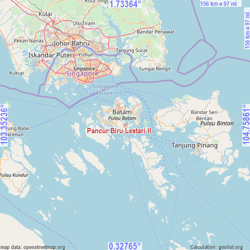
Pancur Biru Lestari II GPS coordinates[2]
1° 1' 50.592" North, 104° 3' 19.728" East
| Map corner | latitude | longitude |
|---|---|---|
| Upper-left | 1.73364°, | 103.35236° |
| Center: | 1.03072°, | 104.05548° |
| Lower-right: | 0.32765°, | 104.75861° |
| Map W x H: | 156.3×156.3 km | = 97.1×97.1mi |
| max Lat: | 5.88969° ⇑3.8% North |
| Pancur Biru Lestari II: | 1.03072° |
| min Lat: | ⇓96.2% South -10.934° |
| min Long | Pancur Biru Les | max Long |
| 95.1345° | 104.05548° | 140.9419° |
| W 4.9%⇐ | ⇒95.1% E |
Elevation
Elevation of Pancur Biru Lestari II is 8 m = 26 ft, and this is 221.7 m = 727 ft below average elevation for this country.
| Max E: |
3185 m = 10449 ft | 93.7% |
| Avg. | 229.7 m = 754 ft | |
| Pancur Biru Lestari II | 8 m = 26 ft | |
Min E: |
-1 m = -3 ft | 6.3% |
See also: Indonesia elevation on elevation.city.
Geographical zone
Pancur Biru Lestari II is located in North Torrid zone (between Equator and Tropic of Cancer). Distance of Equator is 114.6 km =71.2 mi to South.| Distance of | km | miles | from Pancur Biru Lestari II |
|---|---|---|---|
| North Pole | 9892.5 | 6146.9 | to North |
| Arctic Circle | 7286.6 | 4527.7 | to North |
| Tropic Cancer | 2491.3 | 1548 | to North |
| Equator | 114.6 | 71.2 | to South |


Nearby cities:
15 places around Pancur Biru Lestari II: (largest is in red/bold)
• Bandar Seri Bentan
47.3 km =29.4 mi,  86°
86°
• Batam
13.6 km =8.5 mi,  345°
345°
• Belakangpadang
22.5 km =14 mi,  305°
305°
• Khairiahmandah
128.3 km =79.7 mi,  208°
208°
• Kijang
65.9 km =40.9 mi,  102°
102°
• Meral
73.7 km =45.8 mi,  266°
266°
• Moro
49.3 km =30.6 mi,  231°
231°
• Pasirpanjang
79.1 km =49.2 mi,  277°
277°
• Sawang
84.3 km =52.4 mi,  247°
247°
• Sekupang
17.9 km =11.1 mi, 306°
• Tanjung Pinang
46.5 km =28.9 mi,  105°
105°
• Tanjungbatu
77.8 km =48.3 mi,  237°
237°
• Tebing
70.6 km =43.9 mi, 270°
• Telukdalam
103.7 km =64.4 mi, 237°
• Urung
69.3 km =43.1 mi, 246°
Sources, notices
• [Note1] Compared only with cities in Indonesia existing in our database
• [Src1] Map data: © OpenStreetMap contributors (CC-BY-SA)
• [Src2] Other city data from geonames.org with taken over terms of usage.
• [Src3] Geographical zone / Annual Mean Temperature by Robert A. Rohde @ Wikipedia
