Sekupang geodata
Sekupang (Riau Islands) is a seat of a third-order administrative division; located in Indonesia in Asia/Jakarta (GMT+7) time zone. In our database, there are 407 cities with bigger population. Compared to other cities in Indonesia, 96.4% of cities are located further ↓South; 95.2% of cities are located further →East and 68.9% of cities have higher elevation than Sekupang. Note1


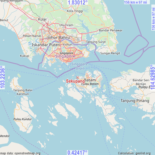
Sekupang GPS coordinates[2]
1° 7' 38.028" North, 103° 55' 36.192" East
| Map corner | latitude | longitude |
|---|---|---|
| Upper-left | 1.83012°, | 103.2236° |
| Center: | 1.12723°, | 103.92672° |
| Lower-right: | 0.42417°, | 104.62985° |
| Map W x H: | 156.3×156.3 km | = 97.1×97.1mi |
| max Lat: | 5.88969° ⇑3.6% North |
| Sekupang: | 1.12723° |
| min Lat: | ⇓96.4% South -10.934° |
| min Long | Sekupang | max Long |
| 95.1345° | 103.92672° | 140.9419° |
| W 4.8%⇐ | ⇒95.2% E |
Elevation
Elevation of Sekupang is 34 m = 112 ft, and this is 195.7 m = 642 ft below average elevation for this country.
| Max E: |
3185 m = 10449 ft | 68.9% |
| Avg. | 229.7 m = 754 ft | |
| Sekupang | 34 m = 112 ft | |
Min E: |
-1 m = -3 ft | 31.1% |
See also: Indonesia elevation on elevation.city.
Geographical zone
Sekupang is located in North Torrid zone (between Equator and Tropic of Cancer). Distance of Equator is 125.3 km =77.9 mi to South.| Distance of | km | miles | from Sekupang |
|---|---|---|---|
| North Pole | 9881.7 | 6140.2 | to North |
| Arctic Circle | 7275.8 | 4521 | to North |
| Tropic Cancer | 2480.6 | 1541.4 | to North |
| Equator | 125.3 | 77.9 | to South |


Nearby cities:
15 places around Sekupang: (largest is in red/bold)
• Bandar Seri Bentan
62 km =38.5 mi,  97°
97°
• Batam
11.2 km =7 mi,  77°
77°
• Belakangpadang
4.6 km =2.9 mi,  302°
302°
• Khairiahmandah
131.9 km =82 mi,  201°
201°
• Kijang
82.5 km =51.3 mi,  107°
107°
• Meral
61.1 km =38 mi,  256°
256°
• Moro
48.1 km =29.9 mi,  210°
210°
• Pancur Biru Lestari II
17.9 km =11.1 mi,  126°
126°
• Pasirpanjang
64.1 km =39.8 mi,  269°
269°
• Sawang
76.8 km =47.7 mi,  235°
235°
• Tanjung Pinang
63.6 km =39.5 mi, 111°
• Tanjungbatu
73.3 km =45.5 mi,  224°
224°
• Tebing
57.2 km =35.5 mi, 259°
• Telukdalam
98.8 km =61.4 mi,  227°
227°
• Urung
62.3 km =38.7 mi, 232°
Sources, notices
• [Note1] Compared only with cities in Indonesia existing in our database
• [Src1] Map data: © OpenStreetMap contributors (CC-BY-SA)
• [Src2] Other city data from geonames.org with taken over terms of usage.
• [Src3] Geographical zone / Annual Mean Temperature by Robert A. Rohde @ Wikipedia
