Moro geodata
Moro (Riau Islands) is a seat of a third-order administrative division; located in Indonesia in Asia/Jakarta (GMT+7) time zone. In our database, there are 407 cities with bigger population. Compared to other cities in Indonesia, 95.8% of cities are located further ↓South; 95.3% of cities are located further →East and 90.6% of cities have higher elevation than Moro. Note1


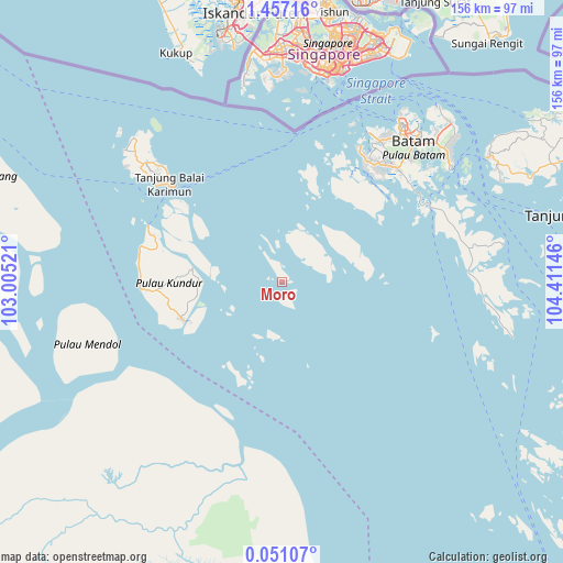
Moro GPS coordinates[2]
0° 45' 15.012" North, 103° 42' 29.988" East
| Map corner | latitude | longitude |
|---|---|---|
| Upper-left | 1.45716°, | 103.00521° |
| Center: | 0.75417°, | 103.70833° |
| Lower-right: | 0.05107°, | 104.41146° |
| Map W x H: | 156.3×156.3 km | = 97.1×97.1mi |
| max Lat: | 5.88969° ⇑4.2% North |
| Moro: | 0.75417° |
| min Lat: | ⇓95.8% South -10.934° |
| min Long | Moro | max Long |
| 95.1345° | 103.70833° | 140.9419° |
| W 4.7%⇐ | ⇒95.3% E |
Elevation
Elevation of Moro is 10 m = 33 ft, and this is 219.7 m = 721 ft below average elevation for this country.
| Max E: |
3185 m = 10449 ft | 90.6% |
| Avg. | 229.7 m = 754 ft | |
| Moro | 10 m = 33 ft | |
Min E: |
-1 m = -3 ft | 9.4% |
See also: Indonesia elevation on elevation.city.
Geographical zone
Moro is located in North Torrid zone (between Equator and Tropic of Cancer). Distance of Equator is 83.9 km =52.1 mi to South.| Distance of | km | miles | from Moro |
|---|---|---|---|
| North Pole | 9923.2 | 6166 | to North |
| Arctic Circle | 7317.3 | 4546.8 | to North |
| Tropic Cancer | 2522.1 | 1567.2 | to North |
| Equator | 83.9 | 52.1 | to South |


Nearby cities:
15 places around Moro: (largest is in red/bold)
• Bandar Seri Bentan
92 km =57.2 mi,  68°
68°
• Batam
56.3 km =35 mi,  38°
38°
• Belakangpadang
48.5 km =30.1 mi,  24°
24°
• Khairiahmandah
84.8 km =52.7 mi,  196°
196°
• Kijang
104.1 km =64.7 mi,  81°
81°
• Meral
44 km =27.3 mi,  307°
307°
• Pancur Biru Lestari II
49.3 km =30.6 mi,  51°
51°
• Pasirpanjang
57.4 km =35.7 mi,  316°
316°
• Sawang
39.2 km =24.4 mi,  267°
267°
• Sekupang
48.1 km =29.9 mi,  30°
30°
• Tanjung Pinang
85.3 km =53 mi, 77°
• Tanjungbatu
29.4 km =18.3 mi,  248°
248°
• Tebing
44.5 km =27.7 mi, 314°
• Telukdalam
55 km =34.2 mi,  243°
243°
• Urung
25.3 km =15.7 mi,  277°
277°
Sources, notices
• [Note1] Compared only with cities in Indonesia existing in our database
• [Src1] Map data: © OpenStreetMap contributors (CC-BY-SA)
• [Src2] Other city data from geonames.org with taken over terms of usage.
• [Src3] Geographical zone / Annual Mean Temperature by Robert A. Rohde @ Wikipedia
