Gunungmenang geodata
Gunungmenang (South Sumatra) is a seat of a third-order administrative division; located in Indonesia in Asia/Jakarta (GMT+7) time zone. In our database, there are 407 cities with bigger population. Compared to other cities in Indonesia, 90.9% of cities are located further ↓South; 95.1% of cities are located further →East and 85.2% of cities have higher elevation than Gunungmenang. Note1


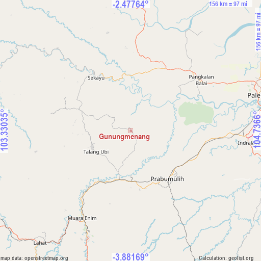
Gunungmenang GPS coordinates[2]
3° 10' 47.64" South, 104° 2' 0.492" East
| Map corner | latitude | longitude |
|---|---|---|
| Upper-left | -2.47764°, | 103.33035° |
| Center: | -3.1799°, | 104.03347° |
| Lower-right: | -3.88169°, | 104.7366° |
| Map W x H: | 156.1×156.1 km | = 97×97mi |
| max Lat: | 5.88969° ⇑9.1% North |
| Gunungmenang: | -3.1799° |
| min Lat: | ⇓90.9% South -10.934° |
| min Long | Gunungmenang | max Long |
| 95.1345° | 104.03347° | 140.9419° |
| W 4.9%⇐ | ⇒95.1% E |
Elevation
Elevation of Gunungmenang is 14 m = 46 ft, and this is 215.7 m = 708 ft below average elevation for this country.
| Max E: |
3185 m = 10449 ft | 85.2% |
| Avg. | 229.7 m = 754 ft | |
| Gunungmenang | 14 m = 46 ft | |
Min E: |
-1 m = -3 ft | 14.8% |
See also: Indonesia elevation on elevation.city.
Geographical zone
Gunungmenang is located in South Torrid zone (between Equator and Tropic of Capricorn). Distance of Equator is 353.6 km =219.7 mi to North.| Distance of | km | miles | from Gunungmenang |
|---|---|---|---|
| Equator | 353.6 | 219.7 | to North |
| Tropic Capricorn | 2252.3 | 1399.5 | to South |
| Antarctic Circle | 7047.6 | 4379.2 | to South |
| South Pole | 9653.5 | 5998.4 | to South |


Nearby cities:
15 places around Gunungmenang: (largest is in red/bold)
• Babat
65.7 km =40.8 mi,  318°
318°
• Glumbang
45.3 km =28.1 mi,  98°
98°
• Gunungmegang Dalam
35.1 km =21.8 mi,  211°
211°
• Indralaya
71.7 km =44.6 mi, 96°
• Muara Enim
59.7 km =37.1 mi, 209°
• Muarakuang
80.2 km =49.8 mi,  132°
132°
• Negeriagung
77.9 km =48.4 mi, 212°
• Pangkalan Balai
52 km =32.3 mi,  50°
50°
• Prabumulih
35.8 km =22.2 mi,  142°
142°
• Sekayu
39.8 km =24.7 mi,  326°
326°
• Suban Jeriji
63.5 km =39.5 mi,  186°
186°
• Sungairotan
28.5 km =17.7 mi,  72°
72°
• Talang Ubi
25 km =15.5 mi,  247°
247°
• Talangbetutu
80.5 km =50 mi, 65°
• Tanjungraja
84.1 km =52.3 mi, 102°
Sources, notices
• [Note1] Compared only with cities in Indonesia existing in our database
• [Src1] Map data: © OpenStreetMap contributors (CC-BY-SA)
• [Src2] Other city data from geonames.org with taken over terms of usage.
• [Src3] Geographical zone / Annual Mean Temperature by Robert A. Rohde @ Wikipedia
