Palembang geodata
Palembang (South Sumatra) is a seat of a first-order administrative division; located in Indonesia in Asia/Jakarta (GMT+7) time zone. With population of 1,441,500 people, there are 5 cities with bigger population in this country. Compared to other cities in Indonesia, 91.5% of cities are located further ↓South; 94.7% of cities are located further →East and 98.5% of cities have higher elevation than Palembang. Note1


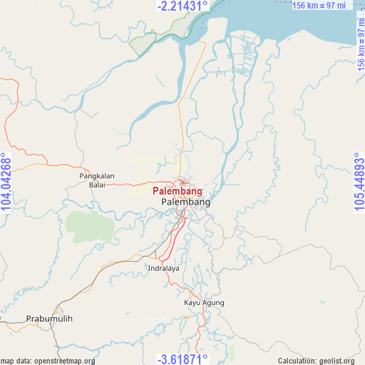
Palembang GPS coordinates[2]
2° 55' 0.228" South, 104° 44' 44.88" East
| Map corner | latitude | longitude |
|---|---|---|
| Upper-left | -2.21431°, | 104.04268° |
| Center: | -2.91673°, | 104.7458° |
| Lower-right: | -3.61871°, | 105.44893° |
| Map W x H: | 156.2×156.2 km | = 97.1×97.1mi |
| max Lat: | 5.88969° ⇑8.5% North |
| Palembang: | -2.91673° |
| min Lat: | ⇓91.5% South -10.934° |
| min Long | Palembang | max Long |
| 95.1345° | 104.7458° | 140.9419° |
| W 5.3%⇐ | ⇒94.7% E |
Elevation
Elevation of Palembang is 5 m = 16 ft, and this is 224.7 m = 737 ft below average elevation for this country.
| Max E: |
3185 m = 10449 ft | 98.5% |
| Avg. | 229.7 m = 754 ft | |
| Palembang | 5 m = 16 ft | |
Min E: |
-1 m = -3 ft | 1.5% |
See also: Palembang elevation on elevation.city.
Geographical zone
Palembang is located in South Torrid zone (between Equator and Tropic of Capricorn). Distance of Equator is 324.3 km =201.5 mi to North.| Distance of | km | miles | from Palembang |
|---|---|---|---|
| Equator | 324.3 | 201.5 | to North |
| Tropic Capricorn | 2281.6 | 1417.7 | to South |
| Antarctic Circle | 7076.9 | 4397.4 | to South |
| South Pole | 9682.8 | 6016.6 | to South |


Nearby cities:
15 places around Palembang: (largest is in red/bold)
• Glumbang
49.6 km =30.8 mi,  223°
223°
• Gunungmenang
84.3 km =52.4 mi,  249°
249°
• Indralaya
38.1 km =23.7 mi,  191°
191°
• Kayu Agung
53.7 km =33.4 mi,  169°
169°
• Muarakuang
85.7 km =53.3 mi, 193°
• Pangkalan Balai
39.2 km =24.4 mi,  275°
275°
• Pedamaran
64.4 km =40 mi, 170°
• Prabumulih
81.2 km =50.5 mi, 224°
• Sungaigerong
13.5 km =8.4 mi,  122°
122°
• Sungairotan
55.9 km =34.7 mi, 248°
• Sungsang
64 km =39.8 mi,  15°
15°
• Talangbetutu
7 km =4.3 mi,  304°
304°
• Tanjung Lubuk
50.4 km =31.3 mi, 167°
• Tanjung Lubuk
67.8 km =42.1 mi,  178°
178°
• Tanjungraja
46.9 km =29.1 mi, 176°
Sources, notices
• [Note1] Compared only with cities in Indonesia existing in our database
• [Src1] Map data: © OpenStreetMap contributors (CC-BY-SA)
• [Src2] Other city data from geonames.org with taken over terms of usage.
• [Src3] Geographical zone / Annual Mean Temperature by Robert A. Rohde @ Wikipedia
