Sokaraja geodata
Sokaraja (Central Java) is a populated place; located in Indonesia in Asia/Jakarta (GMT+7) time zone. With population of 66,482 people, there are 184 cities with bigger population in this country. Compared to other cities in Indonesia, 54.8% of cities are located further ↑North; 66.1% of cities are located further →East and 63.2% of cities have higher elevation than Sokaraja. Note1


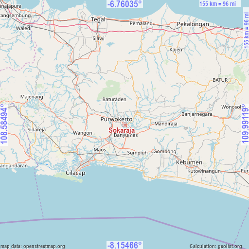
Sokaraja GPS coordinates[2]
7° 27' 29.016" South, 109° 17' 17.016" East
| Map corner | latitude | longitude |
|---|---|---|
| Upper-left | -6.76035°, | 108.58494° |
| Center: | -7.45806°, | 109.28806° |
| Lower-right: | -8.15466°, | 109.99119° |
| Map W x H: | 155×155 km | = 96.3×96.3mi |
| max Lat: | 5.88969° ⇑54.8% North |
| Sokaraja: | -7.45806° |
| min Lat: | ⇓45.2% South -10.934° |
| min Long | Sokaraja | max Long |
| 95.1345° | 109.28806° | 140.9419° |
| W 33.9%⇐ | ⇒66.1% E |
Elevation
Elevation of Sokaraja is 48 m = 157 ft, and this is 181.7 m = 596 ft below average elevation for this country.
| Max E: |
3185 m = 10449 ft | 63.2% |
| Avg. | 229.7 m = 754 ft | |
| Sokaraja | 48 m = 157 ft | |
Min E: |
-1 m = -3 ft | 36.8% |
See also: Sokaraja elevation on elevation.city.
Geographical zone
Sokaraja is located in South Torrid zone (between Equator and Tropic of Capricorn). Distance of Equator is 829.3 km =515.3 mi to North.| Distance of | km | miles | from Sokaraja |
|---|---|---|---|
| Equator | 829.3 | 515.3 | to North |
| Tropic Capricorn | 1776.7 | 1104 | to South |
| Antarctic Circle | 6571.9 | 4083.6 | to South |
| South Pole | 9177.8 | 5702.8 | to South |


Nearby cities:
15 places around Sokaraja: (largest is in red/bold)
• Banyumas
6.3 km =3.9 mi,  173°
173°
• Binangun
9.9 km =6.2 mi,  207°
207°
• Brak
13.5 km =8.4 mi, 213°
• Gambarsari
12.6 km =7.8 mi,  229°
229°
• Gambolempuk
13.7 km =8.5 mi, 206°
• Garbi
9.5 km =5.9 mi,  238°
238°
• Karangjati
15.5 km =9.6 mi, 207°
• Kebasen
12.8 km =8 mi, 229°
• Papringan
6.7 km =4.2 mi,  220°
220°
• Pesawahan
15.2 km =9.4 mi, 240°
• Purbalingga
11.4 km =7.1 mi,  47°
47°
• Purwokerto
7.2 km =4.5 mi,  304°
304°
• Rawalo
14.9 km =9.3 mi, 233°
• Sampang
15.4 km =9.6 mi, 220°
• Sampang Selatan
15.5 km =9.6 mi, 218°
Sources, notices
• [Note1] Compared only with cities in Indonesia existing in our database
• [Src1] Map data: © OpenStreetMap contributors (CC-BY-SA)
• [Src2] Other city data from geonames.org with taken over terms of usage.
• [Src3] Geographical zone / Annual Mean Temperature by Robert A. Rohde @ Wikipedia
