Banyumas geodata
Banyumas (Central Java) is a populated place; located in Indonesia in Asia/Jakarta (GMT+7) time zone. With population of 48,378 people, there are 238 cities with bigger population in this country. Compared to other cities in Indonesia, 56.3% of cities are located further ↑North; 66.1% of cities are located further →East and 72.7% of cities have higher elevation than Banyumas. Note1


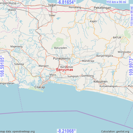
Banyumas GPS coordinates[2]
7° 30' 51.012" South, 109° 17' 39.012" East
| Map corner | latitude | longitude |
|---|---|---|
| Upper-left | -6.81654°, | 108.59105° |
| Center: | -7.51417°, | 109.29417° |
| Lower-right: | -8.21068°, | 109.9973° |
| Map W x H: | 155×155 km | = 96.3×96.3mi |
| max Lat: | 5.88969° ⇑56.3% North |
| Banyumas: | -7.51417° |
| min Lat: | ⇓43.7% South -10.934° |
| min Long | Banyumas | max Long |
| 95.1345° | 109.29417° | 140.9419° |
| W 33.9%⇐ | ⇒66.1% E |
Elevation
Elevation of Banyumas is 28 m = 92 ft, and this is 201.7 m = 662 ft below average elevation for this country.
| Max E: |
3185 m = 10449 ft | 72.7% |
| Avg. | 229.7 m = 754 ft | |
| Banyumas | 28 m = 92 ft | |
Min E: |
-1 m = -3 ft | 27.3% |
See also: Banyumas elevation on elevation.city.
Geographical zone
Banyumas is located in South Torrid zone (between Equator and Tropic of Capricorn). Distance of Equator is 835.5 km =519.2 mi to North.| Distance of | km | miles | from Banyumas |
|---|---|---|---|
| Equator | 835.5 | 519.2 | to North |
| Tropic Capricorn | 1770.4 | 1100.1 | to South |
| Antarctic Circle | 6565.7 | 4079.7 | to South |
| South Pole | 9171.6 | 5699 | to South |


Nearby cities:
15 places around Banyumas: (largest is in red/bold)
• Binangun
5.8 km =3.6 mi,  243°
243°
• Brak
9.6 km =6 mi, 238°
• Gambarsari
10.4 km =6.5 mi,  259°
259°
• Gambolempuk
9.1 km =5.7 mi,  228°
228°
• Garbi
8.9 km =5.5 mi,  278°
278°
• Gununglaban
10.9 km =6.8 mi,  219°
219°
• Karangjati
10.8 km =6.7 mi, 226°
• Kebasen
10.6 km =6.6 mi, 258°
• Papringan
5.2 km =3.2 mi, 282°
• Purwokerto
12.2 km =7.6 mi,  327°
327°
• Rawaseser
10.9 km =6.8 mi,  208°
208°
• Sampang
12.1 km =7.5 mi, 243°
• Sampang Selatan
11.9 km =7.4 mi, 240°
• Sidasari
12.4 km =7.7 mi, 235°
• Sokaraja
6.3 km =3.9 mi,  353°
353°
Sources, notices
• [Note1] Compared only with cities in Indonesia existing in our database
• [Src1] Map data: © OpenStreetMap contributors (CC-BY-SA)
• [Src2] Other city data from geonames.org with taken over terms of usage.
• [Src3] Geographical zone / Annual Mean Temperature by Robert A. Rohde @ Wikipedia
