Purwokerto geodata
Purwokerto (Central Java) is a seat of a second-order administrative division; located in Indonesia in Asia/Jakarta (GMT+7) time zone. With population of 217,222 people, there are 44 cities with bigger population in this country. Compared to other cities in Indonesia, 53.9% of cities are located further ↑North; 66.2% of cities are located further →East and 55.6% of cities have higher elevation than Purwokerto. Note1


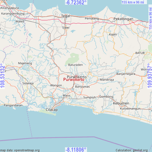
Purwokerto GPS coordinates[2]
7° 25' 17.004" South, 109° 14' 3.984" East
| Map corner | latitude | longitude |
|---|---|---|
| Upper-left | -6.72362°, | 108.53132° |
| Center: | -7.42139°, | 109.23444° |
| Lower-right: | -8.11806°, | 109.93757° |
| Map W x H: | 155×155.1 km | = 96.3×96.4mi |
| max Lat: | 5.88969° ⇑53.9% North |
| Purwokerto: | -7.42139° |
| min Lat: | ⇓46.1% South -10.934° |
| min Long | Purwokerto | max Long |
| 95.1345° | 109.23444° | 140.9419° |
| W 33.8%⇐ | ⇒66.2% E |
Elevation
Elevation of Purwokerto is 81 m = 266 ft, and this is 148.7 m = 488 ft below average elevation for this country.
| Max E: |
3185 m = 10449 ft | 55.6% |
| Avg. | 229.7 m = 754 ft | |
| Purwokerto | 81 m = 266 ft | |
Min E: |
-1 m = -3 ft | 44.4% |
See also: Purwokerto elevation on elevation.city.
Geographical zone
Purwokerto is located in South Torrid zone (between Equator and Tropic of Capricorn). Distance of Equator is 825.2 km =512.8 mi to North.| Distance of | km | miles | from Purwokerto |
|---|---|---|---|
| Equator | 825.2 | 512.8 | to North |
| Tropic Capricorn | 1780.7 | 1106.5 | to South |
| Antarctic Circle | 6576 | 4086.1 | to South |
| South Pole | 9181.9 | 5705.4 | to South |


Nearby cities:
15 places around Purwokerto: (largest is in red/bold)
• Banyumas
12.2 km =7.6 mi,  147°
147°
• Baturaden
13.6 km =8.5 mi,  351°
351°
• Binangun
13 km =8.1 mi,  173°
173°
• Brak
15.4 km =9.6 mi,  185°
185°
• Gambarsari
12.8 km =8 mi,  196°
196°
• Gambolempuk
16.3 km =10.1 mi,  180°
180°
• Garbi
9.2 km =5.7 mi, 193°
• Kebasen
13 km =8.1 mi, 197°
• Papringan
9.3 km =5.8 mi, 170°
• Pesawahan
13.6 km =8.5 mi,  212°
212°
• Purbalingga
14.7 km =9.1 mi,  75°
75°
• Rawalo
14.2 km =8.8 mi, 205°
• Sokaraja
7.2 km =4.5 mi,  124°
124°
• Tipar
13.3 km =8.3 mi,  225°
225°
• Tugu
14.9 km =9.3 mi, 225°
Sources, notices
• [Note1] Compared only with cities in Indonesia existing in our database
• [Src1] Map data: © OpenStreetMap contributors (CC-BY-SA)
• [Src2] Other city data from geonames.org with taken over terms of usage.
• [Src3] Geographical zone / Annual Mean Temperature by Robert A. Rohde @ Wikipedia
