Rokan geodata
Rokan (Riau) is a seat of a third-order administrative division; located in Indonesia in Asia/Jakarta (GMT+7) time zone. In our database, there are 407 cities with bigger population. Compared to other cities in Indonesia, 95.6% of cities are located further ↓South; 97.1% of cities are located further →East and 51.4% of cities have higher elevation than Rokan. Note1


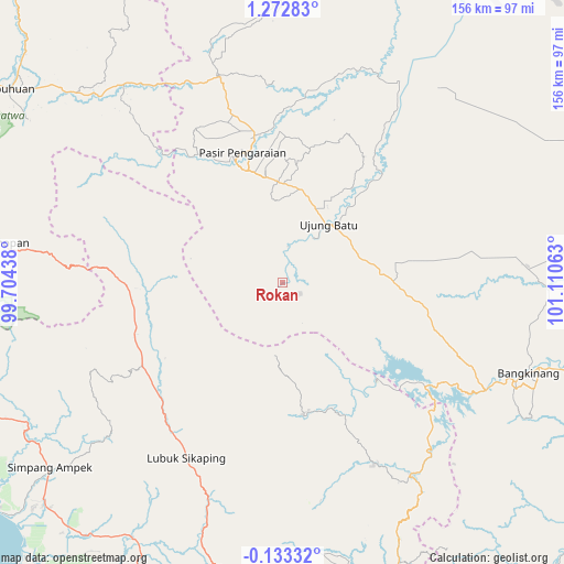
Rokan GPS coordinates[2]
0° 34' 11.28" North, 100° 24' 27" East
| Map corner | latitude | longitude |
|---|---|---|
| Upper-left | 1.27283°, | 99.70438° |
| Center: | 0.5698°, | 100.4075° |
| Lower-right: | -0.13332°, | 101.11063° |
| Map W x H: | 156.3×156.4 km | = 97.1×97.2mi |
| max Lat: | 5.88969° ⇑4.4% North |
| Rokan: | 0.5698° |
| min Lat: | ⇓95.6% South -10.934° |
| min Long | Rokan | max Long |
| 95.1345° | 100.4075° | 140.9419° |
| W 2.9%⇐ | ⇒97.1% E |
Elevation
Elevation of Rokan is 97 m = 318 ft, and this is 132.7 m = 435 ft below average elevation for this country.
| Max E: |
3185 m = 10449 ft | 51.4% |
| Avg. | 229.7 m = 754 ft | |
| Rokan | 97 m = 318 ft | |
Min E: |
-1 m = -3 ft | 48.6% |
See also: Indonesia elevation on elevation.city.
Geographical zone
Rokan is located in North Torrid zone (between Equator and Tropic of Cancer). Distance of Equator is 63.4 km =39.4 mi to South.| Distance of | km | miles | from Rokan |
|---|---|---|---|
| North Pole | 9943.7 | 6178.7 | to North |
| Arctic Circle | 7337.8 | 4559.5 | to North |
| Tropic Cancer | 2542.6 | 1579.9 | to North |
| Equator | 63.4 | 39.4 | to South |


Nearby cities:
15 places around Rokan: (largest is in red/bold)
• Bangkinang
73.2 km =45.5 mi,  110°
110°
• Bonjol
68.3 km =42.4 mi,  197°
197°
• Dalududalu
59.7 km =37.1 mi,  342°
342°
• Guguk
80.4 km =50 mi,  168°
168°
• Kotanopan
78.4 km =48.7 mi,  277°
277°
• Kotatengah
59.8 km =37.2 mi,  15°
15°
• Lubuk Sikaping
54.4 km =33.8 mi,  209°
209°
• Muara Sipongi
43.9 km =27.3 mi,  269°
269°
• Panti
45.5 km =28.3 mi,  239°
239°
• Pasarujungbatu
72.7 km =45.2 mi,  315°
315°
• Pasir Pengaraian
35.1 km =21.8 mi, 339°
• Sarilamak
85 km =52.8 mi,  160°
160°
• Simpang Empat
83.6 km =51.9 mi,  231°
231°
• Talu
60.6 km =37.7 mi, 231°
• Ujungbatu
74.3 km =46.2 mi,  314°
314°
Sources, notices
• [Note1] Compared only with cities in Indonesia existing in our database
• [Src1] Map data: © OpenStreetMap contributors (CC-BY-SA)
• [Src2] Other city data from geonames.org with taken over terms of usage.
• [Src3] Geographical zone / Annual Mean Temperature by Robert A. Rohde @ Wikipedia
