Pauh geodata
Pauh (Jambi) is a seat of a third-order administrative division; located in Indonesia in Asia/Jakarta (GMT+7) time zone. In our database, there are 407 cities with bigger population. Compared to other cities in Indonesia, 92.7% of cities are located further ↓South; 95.8% of cities are located further →East and 66.1% of cities have higher elevation than Pauh. Note1


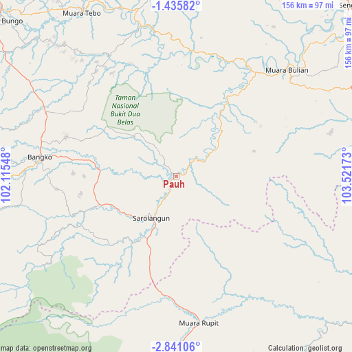
Pauh GPS coordinates[2]
2° 8' 18.96" South, 102° 49' 6.96" East
| Map corner | latitude | longitude |
|---|---|---|
| Upper-left | -1.43582°, | 102.11548° |
| Center: | -2.1386°, | 102.8186° |
| Lower-right: | -2.84106°, | 103.52173° |
| Map W x H: | 156.2×156.3 km | = 97.1×97.1mi |
| max Lat: | 5.88969° ⇑7.3% North |
| Pauh: | -2.1386° |
| min Lat: | ⇓92.7% South -10.934° |
| min Long | Pauh | max Long |
| 95.1345° | 102.8186° | 140.9419° |
| W 4.2%⇐ | ⇒95.8% E |
Elevation
Elevation of Pauh is 40 m = 131 ft, and this is 189.7 m = 622 ft below average elevation for this country.
| Max E: |
3185 m = 10449 ft | 66.1% |
| Avg. | 229.7 m = 754 ft | |
| Pauh | 40 m = 131 ft | |
Min E: |
-1 m = -3 ft | 33.9% |
See also: Indonesia elevation on elevation.city.
Geographical zone
Pauh is located in South Torrid zone (between Equator and Tropic of Capricorn). Distance of Equator is 237.8 km =147.8 mi to North.| Distance of | km | miles | from Pauh |
|---|---|---|---|
| Equator | 237.8 | 147.8 | to North |
| Tropic Capricorn | 2368.1 | 1471.5 | to South |
| Antarctic Circle | 7163.4 | 4451.1 | to South |
| South Pole | 9769.3 | 6070.4 | to South |


Nearby cities:
15 places around Pauh: (largest is in red/bold)
• Bangko
62.7 km =39 mi,  276°
276°
• Bejubang Dua
67.4 km =41.9 mi,  55°
55°
• Bingintelok
63.3 km =39.3 mi,  148°
148°
• Mersam
52.9 km =32.9 mi,  22°
22°
• Muara Bulian
68.1 km =42.3 mi,  45°
45°
• Muara Tebo
84.7 km =52.6 mi,  330°
330°
• Muara Tembesi
58.1 km =36.1 mi,  34°
34°
• Muaralimun
35 km =21.7 mi,  214°
214°
• Muararupit
65.8 km =40.9 mi,  171°
171°
• Muarasiau
81.2 km =50.5 mi,  259°
259°
• Rantaupangiang
74.6 km =46.4 mi,  237°
237°
• Rantaupanjang
65.5 km =40.7 mi,  299°
299°
• Sarolangun
21.8 km =13.5 mi, 207°
• Sungaibengkal
67.9 km =42.2 mi,  350°
350°
• Surulangun Rawas
54.2 km =33.7 mi,  186°
186°
Sources, notices
• [Note1] Compared only with cities in Indonesia existing in our database
• [Src1] Map data: © OpenStreetMap contributors (CC-BY-SA)
• [Src2] Other city data from geonames.org with taken over terms of usage.
• [Src3] Geographical zone / Annual Mean Temperature by Robert A. Rohde @ Wikipedia
