Surulangun Rawas geodata
Surulangun Rawas (South Sumatra) is a seat of a third-order administrative division; located in Indonesia in Asia/Jakarta (GMT+7) time zone. In our database, there are 407 cities with bigger population. Compared to other cities in Indonesia, 92% of cities are located further ↓South; 95.8% of cities are located further →East and 60.1% of cities have higher elevation than Surulangun Rawas. Note1


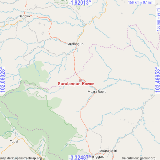
Surulangun Rawas GPS coordinates[2]
2° 37' 21.72" South, 102° 45' 48.24" East
| Map corner | latitude | longitude |
|---|---|---|
| Upper-left | -1.92013°, | 102.06028° |
| Center: | -2.6227°, | 102.7634° |
| Lower-right: | -3.32487°, | 103.46653° |
| Map W x H: | 156.2×156.2 km | = 97.1×97.1mi |
| max Lat: | 5.88969° ⇑8% North |
| Surulangun Rawas: | -2.6227° |
| min Lat: | ⇓92% South -10.934° |
| min Long | Surulangun Rawa | max Long |
| 95.1345° | 102.7634° | 140.9419° |
| W 4.2%⇐ | ⇒95.8% E |
Elevation
Elevation of Surulangun Rawas is 59 m = 194 ft, and this is 170.7 m = 560 ft below average elevation for this country.
| Max E: |
3185 m = 10449 ft | 60.1% |
| Avg. | 229.7 m = 754 ft | |
| Surulangun Rawas | 59 m = 194 ft | |
Min E: |
-1 m = -3 ft | 39.9% |
See also: Indonesia elevation on elevation.city.
Geographical zone
Surulangun Rawas is located in South Torrid zone (between Equator and Tropic of Capricorn). Distance of Equator is 291.6 km =181.2 mi to North.| Distance of | km | miles | from Surulangun Rawas |
|---|---|---|---|
| Equator | 291.6 | 181.2 | to North |
| Tropic Capricorn | 2314.3 | 1438 | to South |
| Antarctic Circle | 7109.6 | 4417.7 | to South |
| South Pole | 9715.4 | 6036.9 | to South |


Nearby cities:
15 places around Surulangun Rawas: (largest is in red/bold)
• Bangko
82.5 km =51.3 mi,  317°
317°
• Bingintelok
39.3 km =24.4 mi,  90°
90°
• Jangkat
79.8 km =49.6 mi,  279°
279°
• Lubuklinggau
75.5 km =46.9 mi,  171°
171°
• Muara Beliti
75.8 km =47.1 mi,  156°
156°
• Muaralakitan
65.5 km =40.7 mi,  113°
113°
• Muaralimun
28.7 km =17.8 mi,  331°
331°
• Muararupit
19.8 km =12.3 mi,  124°
124°
• Muarasiau
83.3 km =51.8 mi,  297°
297°
• Padangulaktanding
83.7 km =52 mi,  177°
177°
• Pauh
54.2 km =33.7 mi,  6°
6°
• Rantaupangiang
58.7 km =36.5 mi, 283°
• Sarolangun
34.8 km =21.6 mi,  353°
353°
• Terawas
48.1 km =29.9 mi, 173°
• Tubei
83.4 km =51.8 mi,  228°
228°
Sources, notices
• [Note1] Compared only with cities in Indonesia existing in our database
• [Src1] Map data: © OpenStreetMap contributors (CC-BY-SA)
• [Src2] Other city data from geonames.org with taken over terms of usage.
• [Src3] Geographical zone / Annual Mean Temperature by Robert A. Rohde @ Wikipedia
