Rantaupangiang geodata
Rantaupangiang (Jambi) is a seat of a third-order administrative division; located in Indonesia in Asia/Jakarta (GMT+7) time zone. In our database, there are 407 cities with bigger population. Compared to other cities in Indonesia, 92.2% of cities are located further ↓South; 96% of cities are located further →East and 62.8% of cities have lower elevation than Rantaupangiang. Note1


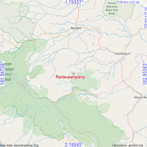
Rantaupangiang GPS coordinates[2]
2° 29' 46.32" South, 102° 15' 1.8" East
| Map corner | latitude | longitude |
|---|---|---|
| Upper-left | -1.79357°, | 101.54738° |
| Center: | -2.4962°, | 102.2505° |
| Lower-right: | -3.19845°, | 102.95363° |
| Map W x H: | 156.2×156.2 km | = 97.1×97.1mi |
| max Lat: | 5.88969° ⇑7.8% North |
| Rantaupangiang: | -2.4962° |
| min Lat: | ⇓92.2% South -10.934° |
| min Long | Rantaupangiang | max Long |
| 95.1345° | 102.2505° | 140.9419° |
| W 4%⇐ | ⇒96% E |
Elevation
Elevation of Rantaupangiang is 194 m = 636 ft, and this is 35.7 m = 117 ft below average elevation for this country.
| Max E: |
3185 m = 10449 ft | 37.2% |
| Avg. | 229.7 m = 754 ft | |
| Rantaupangiang | 194 m = 636 ft | |
Min E: |
-1 m = -3 ft | 62.8% |
See also: Indonesia elevation on elevation.city.
Geographical zone
Rantaupangiang is located in South Torrid zone (between Equator and Tropic of Capricorn). Distance of Equator is 277.6 km =172.5 mi to North.| Distance of | km | miles | from Rantaupangiang |
|---|---|---|---|
| Equator | 277.6 | 172.5 | to North |
| Tropic Capricorn | 2328.4 | 1446.8 | to South |
| Antarctic Circle | 7123.6 | 4426.4 | to South |
| South Pole | 9729.5 | 6045.6 | to South |


Nearby cities:
15 places around Rantaupangiang: (largest is in red/bold)
• Argamakmur
103.3 km =64.2 mi,  183°
183°
• Bangko
46.3 km =28.8 mi,  0°
0°
• Bingintelok
97.3 km =60.5 mi,  98°
98°
• Ipuh
102.4 km =63.6 mi,  236°
236°
• Jangkat
21.9 km =13.6 mi,  266°
266°
• Muaralimun
44.5 km =27.7 mi,  75°
75°
• Muararupit
77.6 km =48.2 mi,  109°
109°
• Muarasiau
29.9 km =18.6 mi,  325°
325°
• Pauh
74.6 km =46.4 mi,  57°
57°
• Rantaupanjang
72.7 km =45.2 mi,  5°
5°
• Sarolangun
56.8 km =35.3 mi,  68°
68°
• Sungai Penuh
107.3 km =66.7 mi,  297°
297°
• Surulangun Rawas
58.7 km =36.5 mi, 103°
• Terawas
88.1 km =54.7 mi,  134°
134°
• Tubei
69.5 km =43.2 mi, 184°
Sources, notices
• [Note1] Compared only with cities in Indonesia existing in our database
• [Src1] Map data: © OpenStreetMap contributors (CC-BY-SA)
• [Src2] Other city data from geonames.org with taken over terms of usage.
• [Src3] Geographical zone / Annual Mean Temperature by Robert A. Rohde @ Wikipedia
