Diwek geodata
Diwek (East Java) is a populated place; located in Indonesia in Asia/Jakarta (GMT+7) time zone. With population of 41,719 people, there are 264 cities with bigger population in this country. Compared to other cities in Indonesia, 57.7% of cities are located further ↑North; 51.7% of cities are located further ←West and 61.6% of cities have higher elevation than Diwek. Note1


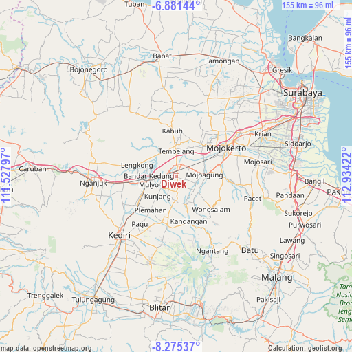
Diwek GPS coordinates[2]
7° 34' 44.292" South, 112° 13' 51.924" East
| Map corner | latitude | longitude |
|---|---|---|
| Upper-left | -6.88144°, | 111.52797° |
| Center: | -7.57897°, | 112.23109° |
| Lower-right: | -8.27537°, | 112.93422° |
| Map W x H: | 155×155 km | = 96.3×96.3mi |
| max Lat: | 5.88969° ⇑57.7% North |
| Diwek: | -7.57897° |
| min Lat: | ⇓42.3% South -10.934° |
| min Long | Diwek | max Long |
| 95.1345° | 112.23109° | 140.9419° |
| W 51.7%⇐ | ⇒48.3% E |
Elevation
Elevation of Diwek is 53 m = 174 ft, and this is 176.7 m = 580 ft below average elevation for this country.
| Max E: |
3185 m = 10449 ft | 61.6% |
| Avg. | 229.7 m = 754 ft | |
| Diwek | 53 m = 174 ft | |
Min E: |
-1 m = -3 ft | 38.4% |
See also: Diwek elevation on elevation.city.
Geographical zone
Diwek is located in South Torrid zone (between Equator and Tropic of Capricorn). Distance of Equator is 842.7 km =523.6 mi to North.| Distance of | km | miles | from Diwek |
|---|---|---|---|
| Equator | 842.7 | 523.6 | to North |
| Tropic Capricorn | 1763.2 | 1095.6 | to South |
| Antarctic Circle | 6558.5 | 4075.3 | to South |
| South Pole | 9164.4 | 5694.5 | to South |


Nearby cities:
15 places around Diwek: (largest is in red/bold)
• Batu
46 km =28.6 mi,  134°
134°
• Gampengrejo
31.5 km =19.6 mi,  228°
228°
• Jombang
3.7 km =2.3 mi,  3°
3°
• Kediri
35.5 km =22.1 mi,  221°
221°
• Kertosono
14.5 km =9 mi,  268°
268°
• Krian
42.7 km =26.5 mi,  63°
63°
• Mojoagung
13.2 km =8.2 mi,  84°
84°
• Mojokerto
25.6 km =15.9 mi, 60°
• Mojosari
36.8 km =22.9 mi, 79°
• Nganjuk
36.2 km =22.5 mi, 265°
• Ngasem
32.8 km =20.4 mi, 219°
• Ngoro
12 km =7.5 mi,  165°
165°
• Pare
21.3 km =13.2 mi,  189°
189°
• Prigen
44 km =27.3 mi,  105°
105°
• Soko
24.1 km =15 mi, 63°
Sources, notices
• [Note1] Compared only with cities in Indonesia existing in our database
• [Src1] Map data: © OpenStreetMap contributors (CC-BY-SA)
• [Src2] Other city data from geonames.org with taken over terms of usage.
• [Src3] Geographical zone / Annual Mean Temperature by Robert A. Rohde @ Wikipedia
