Kertosono geodata
Kertosono (East Java) is a populated place; located in Indonesia in Asia/Jakarta (GMT+7) time zone. With population of 60,782 people, there are 197 cities with bigger population in this country. Compared to other cities in Indonesia, 57.8% of cities are located further ↑North; 50.9% of cities are located further ←West and 64.8% of cities have higher elevation than Kertosono. Note1


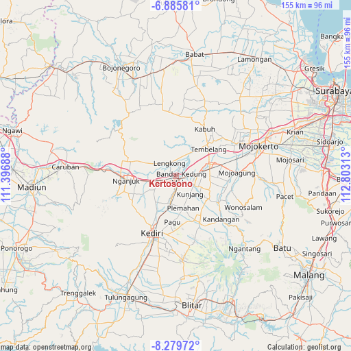
Kertosono GPS coordinates[2]
7° 34' 59.988" South, 112° 6' 0" East
| Map corner | latitude | longitude |
|---|---|---|
| Upper-left | -6.88581°, | 111.39688° |
| Center: | -7.58333°, | 112.1° |
| Lower-right: | -8.27972°, | 112.80313° |
| Map W x H: | 155×155 km | = 96.3×96.3mi |
| max Lat: | 5.88969° ⇑57.8% North |
| Kertosono: | -7.58333° |
| min Lat: | ⇓42.2% South -10.934° |
| min Long | Kertosono | max Long |
| 95.1345° | 112.1° | 140.9419° |
| W 50.9%⇐ | ⇒49.1% E |
Elevation
Elevation of Kertosono is 43 m = 141 ft, and this is 186.7 m = 613 ft below average elevation for this country.
| Max E: |
3185 m = 10449 ft | 64.8% |
| Avg. | 229.7 m = 754 ft | |
| Kertosono | 43 m = 141 ft | |
Min E: |
-1 m = -3 ft | 35.2% |
See also: Kertosono elevation on elevation.city.
Geographical zone
Kertosono is located in South Torrid zone (between Equator and Tropic of Capricorn). Distance of Equator is 843.2 km =523.9 mi to North.| Distance of | km | miles | from Kertosono |
|---|---|---|---|
| Equator | 843.2 | 523.9 | to North |
| Tropic Capricorn | 1762.7 | 1095.3 | to South |
| Antarctic Circle | 6558 | 4075 | to South |
| South Pole | 9163.9 | 5694.2 | to South |


Nearby cities:
15 places around Kertosono: (largest is in red/bold)
• Caruban
49.1 km =30.5 mi,  275°
275°
• Diwek
14.5 km =9 mi,  88°
88°
• Gampengrejo
22.4 km =13.9 mi,  204°
204°
• Jombang
15.2 km =9.4 mi,  74°
74°
• Kediri
27.5 km =17.1 mi, 199°
• Mojoagung
27.6 km =17.1 mi, 86°
• Mojokerto
39 km =24.2 mi, 70°
• Ngamba
49.6 km =30.8 mi,  194°
194°
• Nganjuk
21.8 km =13.5 mi,  263°
263°
• Ngasem
25.6 km =15.9 mi, 194°
• Ngoro
20.7 km =12.9 mi,  122°
122°
• Pare
23.2 km =14.4 mi,  152°
152°
• Pulerejo
49.8 km =30.9 mi, 200°
• Soko
37.7 km =23.4 mi, 72°
• Temenggungan
48.3 km =30 mi, 195°
Sources, notices
• [Note1] Compared only with cities in Indonesia existing in our database
• [Src1] Map data: © OpenStreetMap contributors (CC-BY-SA)
• [Src2] Other city data from geonames.org with taken over terms of usage.
• [Src3] Geographical zone / Annual Mean Temperature by Robert A. Rohde @ Wikipedia
