Mojoagung geodata
Mojoagung (East Java) is a populated place; located in Indonesia in Asia/Jakarta (GMT+7) time zone. With population of 23,534 people, there are 361 cities with bigger population in this country. Compared to other cities in Indonesia, 57.5% of cities are located further ↑North; 52.8% of cities are located further ←West and 67.4% of cities have higher elevation than Mojoagung. Note1


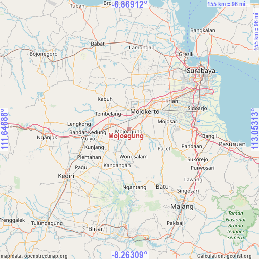
Mojoagung GPS coordinates[2]
7° 34' 0.012" South, 112° 21' 0" East
| Map corner | latitude | longitude |
|---|---|---|
| Upper-left | -6.86912°, | 111.64688° |
| Center: | -7.56667°, | 112.35° |
| Lower-right: | -8.26309°, | 113.05313° |
| Map W x H: | 155×155 km | = 96.3×96.3mi |
| max Lat: | 5.88969° ⇑57.5% North |
| Mojoagung: | -7.56667° |
| min Lat: | ⇓42.5% South -10.934° |
| min Long | Mojoagung | max Long |
| 95.1345° | 112.35° | 140.9419° |
| W 52.8%⇐ | ⇒47.2% E |
Elevation
Elevation of Mojoagung is 37 m = 121 ft, and this is 192.7 m = 632 ft below average elevation for this country.
| Max E: |
3185 m = 10449 ft | 67.4% |
| Avg. | 229.7 m = 754 ft | |
| Mojoagung | 37 m = 121 ft | |
Min E: |
-1 m = -3 ft | 32.6% |
See also: Indonesia elevation on elevation.city.
Geographical zone
Mojoagung is located in South Torrid zone (between Equator and Tropic of Capricorn). Distance of Equator is 841.3 km =522.8 mi to North.| Distance of | km | miles | from Mojoagung |
|---|---|---|---|
| Equator | 841.3 | 522.8 | to North |
| Tropic Capricorn | 1764.6 | 1096.5 | to South |
| Antarctic Circle | 6559.8 | 4076.1 | to South |
| South Pole | 9165.7 | 5695.3 | to South |


Nearby cities:
15 places around Mojoagung: (largest is in red/bold)
• Batu
39 km =24.2 mi,  149°
149°
• Diwek
13.2 km =8.2 mi,  264°
264°
• Driyorejo
37.4 km =23.2 mi,  53°
53°
• Jombang
13.1 km =8.1 mi,  280°
280°
• Kertosono
27.6 km =17.1 mi,  266°
266°
• Krian
30.7 km =19.1 mi,  55°
55°
• Mojokerto
14.5 km =9 mi,  39°
39°
• Mojosari
23.7 km =14.7 mi,  77°
77°
• Ngoro
16.5 km =10.3 mi,  217°
217°
• Pandaan
38.4 km =23.9 mi,  104°
104°
• Pare
27.9 km =17.3 mi, 216°
• Prigen
32.1 km =19.9 mi,  113°
113°
• Soko
12.6 km =7.8 mi, 42°
• Tanggulangin
39.3 km =24.4 mi, 79°
• Tulangan Utara
34.7 km =21.6 mi,  72°
72°
Sources, notices
• [Note1] Compared only with cities in Indonesia existing in our database
• [Src1] Map data: © OpenStreetMap contributors (CC-BY-SA)
• [Src2] Other city data from geonames.org with taken over terms of usage.
• [Src3] Geographical zone / Annual Mean Temperature by Robert A. Rohde @ Wikipedia
