Muntok geodata
Muntok (Bangka–Belitung Islands) is a seat of a second-order administrative division; located in Indonesia in Asia/Jakarta (GMT+7) time zone. With population of 26,709 people, there are 342 cities with bigger population in this country. Compared to other cities in Indonesia, 92.9% of cities are located further ↓South; 94.5% of cities are located further →East and 93.7% of cities have higher elevation than Muntok. Note1


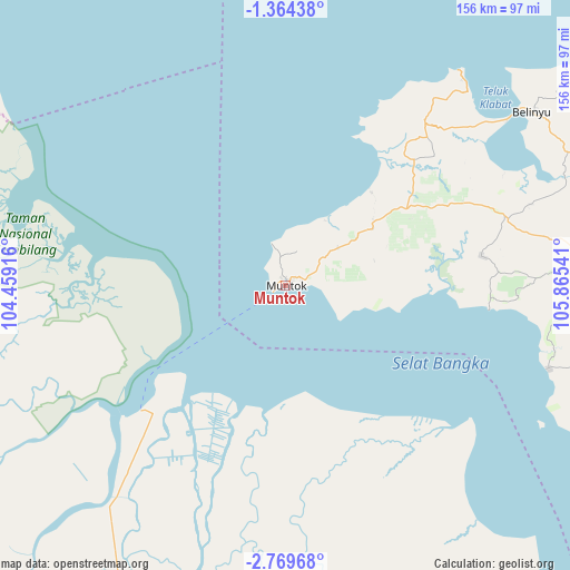
Muntok GPS coordinates[2]
2° 4' 1.884" South, 105° 9' 44.208" East
| Map corner | latitude | longitude |
|---|---|---|
| Upper-left | -1.36438°, | 104.45916° |
| Center: | -2.06719°, | 105.16228° |
| Lower-right: | -2.76968°, | 105.86541° |
| Map W x H: | 156.3×156.3 km | = 97.1×97.1mi |
| max Lat: | 5.88969° ⇑7.1% North |
| Muntok: | -2.06719° |
| min Lat: | ⇓92.9% South -10.934° |
| min Long | Muntok | max Long |
| 95.1345° | 105.16228° | 140.9419° |
| W 5.5%⇐ | ⇒94.5% E |
Elevation
Elevation of Muntok is 8 m = 26 ft, and this is 221.7 m = 727 ft below average elevation for this country.
| Max E: |
3185 m = 10449 ft | 93.7% |
| Avg. | 229.7 m = 754 ft | |
| Muntok | 8 m = 26 ft | |
Min E: |
-1 m = -3 ft | 6.3% |
See also: Indonesia elevation on elevation.city.
Geographical zone
Muntok is located in South Torrid zone (between Equator and Tropic of Capricorn). Distance of Equator is 229.8 km =142.8 mi to North.| Distance of | km | miles | from Muntok |
|---|---|---|---|
| Equator | 229.8 | 142.8 | to North |
| Tropic Capricorn | 2376.1 | 1476.4 | to South |
| Antarctic Circle | 7171.3 | 4456 | to South |
| South Pole | 9777.2 | 6075.3 | to South |


Nearby cities:
15 places around Muntok: (largest is in red/bold)
• Indralaya
142.4 km =88.5 mi,  202°
202°
• Jebus
48.6 km =30.2 mi,  42°
42°
• Kelapa
60.9 km =37.8 mi,  69°
69°
• Koba
146.3 km =90.9 mi,  108°
108°
• Mislak
49.7 km =30.9 mi, 40°
• Palembang
105.2 km =65.4 mi,  206°
206°
• Pangkalan Balai
124.4 km =77.3 mi,  223°
223°
• Pangkalpinang
105.9 km =65.8 mi,  93°
93°
• Sungaigerong
107.5 km =66.8 mi, 198°
• Sungailiat
109.3 km =67.9 mi,  77°
77°
• Sungsang
43.7 km =27.2 mi, 221°
• Talangbetutu
104.4 km =64.9 mi, 209°
• Tanjung Lubuk
148 km =92 mi,  193°
193°
• Tanjungraja
147.6 km =91.7 mi, 196°
• Teritip
34.7 km =21.6 mi, 41°
Sources, notices
• [Note1] Compared only with cities in Indonesia existing in our database
• [Src1] Map data: © OpenStreetMap contributors (CC-BY-SA)
• [Src2] Other city data from geonames.org with taken over terms of usage.
• [Src3] Geographical zone / Annual Mean Temperature by Robert A. Rohde @ Wikipedia
