Sungailiat geodata
Sungailiat (Bangka–Belitung Islands) is a seat of a second-order administrative division; located in Indonesia in Asia/Jakarta (GMT+7) time zone. With population of 74,719 people, there are 172 cities with bigger population in this country. Compared to other cities in Indonesia, 93% of cities are located further ↓South; 89.2% of cities are located further →East and 99.1% of cities have higher elevation than Sungailiat. Note1


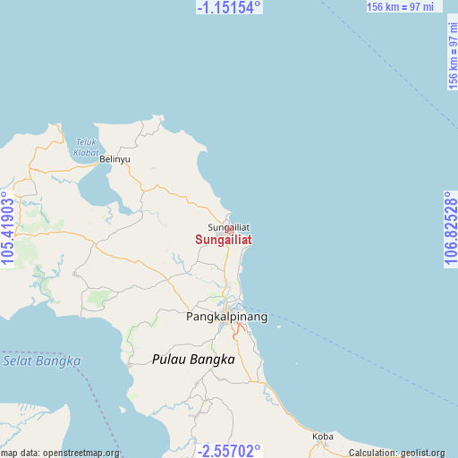
Sungailiat GPS coordinates[2]
1° 51' 15.912" South, 106° 7' 19.74" East
| Map corner | latitude | longitude |
|---|---|---|
| Upper-left | -1.15154°, | 105.41903° |
| Center: | -1.85442°, | 106.12215° |
| Lower-right: | -2.55702°, | 106.82528° |
| Map W x H: | 156.3×156.3 km | = 97.1×97.1mi |
| max Lat: | 5.88969° ⇑7% North |
| Sungailiat: | -1.85442° |
| min Lat: | ⇓93% South -10.934° |
| min Long | Sungailiat | max Long |
| 95.1345° | 106.12215° | 140.9419° |
| W 10.8%⇐ | ⇒89.2% E |
Elevation
Elevation of Sungailiat is 4 m = 13 ft, and this is 225.7 m = 740 ft below average elevation for this country.
| Max E: |
3185 m = 10449 ft | 99.1% |
| Avg. | 229.7 m = 754 ft | |
| Sungailiat | 4 m = 13 ft | |
Min E: |
-1 m = -3 ft | 0.9% |
See also: Sungailiat elevation on elevation.city.
Geographical zone
Sungailiat is located in South Torrid zone (between Equator and Tropic of Capricorn). Distance of Equator is 206.2 km =128.1 mi to North.| Distance of | km | miles | from Sungailiat |
|---|---|---|---|
| Equator | 206.2 | 128.1 | to North |
| Tropic Capricorn | 2399.7 | 1491.1 | to South |
| Antarctic Circle | 7195 | 4470.8 | to South |
| South Pole | 9800.9 | 6090 | to South |


Nearby cities:
15 places around Sungailiat: (largest is in red/bold)
• Jebus
75.1 km =46.7 mi,  279°
279°
• Kelapa
49.6 km =30.8 mi,  267°
267°
• Kepoh
130.5 km =81.1 mi,  158°
158°
• Koba
77.8 km =48.3 mi, 155°
• Mislak
75.7 km =47 mi, 280°
• Muntok
109.3 km =67.9 mi,  257°
257°
• Palembang
193.2 km =120 mi,  232°
232°
• Pangkalpinang
30.6 km =19 mi,  181°
181°
• Sungaigerong
189 km =117.4 mi, 228°
• Sungsang
146.7 km =91.2 mi,  247°
247°
• Talangbetutu
195.5 km =121.5 mi, 234°
• Tanjung Lubuk
219.6 km =136.5 mi,  220°
220°
• Tanjung Pandan
194.4 km =120.8 mi,  120°
120°
• Tanjungraja
222.7 km =138.4 mi, 222°
• Teritip
83.6 km =51.9 mi, 271°
Sources, notices
• [Note1] Compared only with cities in Indonesia existing in our database
• [Src1] Map data: © OpenStreetMap contributors (CC-BY-SA)
• [Src2] Other city data from geonames.org with taken over terms of usage.
• [Src3] Geographical zone / Annual Mean Temperature by Robert A. Rohde @ Wikipedia
