Kresek geodata
Kresek (West Java) is a populated place; located in Indonesia in Asia/Jakarta (GMT+7) time zone. With population of 110,182 people, there are 119 cities with bigger population in this country. Compared to other cities in Indonesia, 87.8% of cities are located further ↓South; 88% of cities are located further →East and 83% of cities have higher elevation than Kresek. Note1


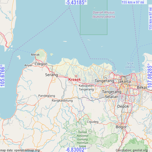
Kresek GPS coordinates[2]
6° 7' 53.004" South, 106° 22' 46.992" East
| Map corner | latitude | longitude |
|---|---|---|
| Upper-left | -5.43185°, | 105.6766° |
| Center: | -6.13139°, | 106.37972° |
| Lower-right: | -6.83002°, | 107.08285° |
| Map W x H: | 155.5×155.5 km | = 96.6×96.6mi |
| max Lat: | 5.88969° ⇑12.2% North |
| Kresek: | -6.13139° |
| min Lat: | ⇓87.8% South -10.934° |
| min Long | Kresek | max Long |
| 95.1345° | 106.37972° | 140.9419° |
| W 12%⇐ | ⇒88% E |
Elevation
Elevation of Kresek is 16 m = 52 ft, and this is 213.7 m = 701 ft below average elevation for this country.
| Max E: |
3185 m = 10449 ft | 83% |
| Avg. | 229.7 m = 754 ft | |
| Kresek | 16 m = 52 ft | |
Min E: |
-1 m = -3 ft | 17% |
See also: Kresek elevation on elevation.city.
Geographical zone
Kresek is located in South Torrid zone (between Equator and Tropic of Capricorn). Distance of Equator is 681.7 km =423.6 mi to North.| Distance of | km | miles | from Kresek |
|---|---|---|---|
| Equator | 681.7 | 423.6 | to North |
| Tropic Capricorn | 1924.2 | 1195.6 | to South |
| Antarctic Circle | 6719.4 | 4175.2 | to South |
| South Pole | 9325.3 | 5794.5 | to South |


Nearby cities:
15 places around Kresek: (largest is in red/bold)
• Cikupa
18.4 km =11.4 mi,  129°
129°
• Ciruas
16.3 km =10.1 mi,  272°
272°
• Curug
24.6 km =15.3 mi, 127°
• Karangdawa Barat
29.7 km =18.5 mi, 269°
• Langgen
18.4 km =11.4 mi,  333°
333°
• Lontar
19.7 km =12.2 mi,  335°
335°
• Padukan
30.5 km =19 mi, 266°
• Pasagipasir
29.1 km =18.1 mi,  258°
258°
• Pasarkemis
17.2 km =10.7 mi,  104°
104°
• Rangkasbitung
29.1 km =18.1 mi,  209°
209°
• Sepatan
21.6 km =13.4 mi,  86°
86°
• Serang
25 km =15.5 mi, 274°
• Tangerang
28.2 km =17.5 mi, 100°
• Teluknaga
28.8 km =17.9 mi,  82°
82°
• Tigaraksa
18.3 km =11.4 mi, 125°
Sources, notices
• [Note1] Compared only with cities in Indonesia existing in our database
• [Src1] Map data: © OpenStreetMap contributors (CC-BY-SA)
• [Src2] Other city data from geonames.org with taken over terms of usage.
• [Src3] Geographical zone / Annual Mean Temperature by Robert A. Rohde @ Wikipedia
