Curug geodata
Curug (Banten) is a populated place; located in Indonesia in Asia/Jakarta (GMT+7) time zone. With population of 191,406 people, there are 56 cities with bigger population in this country. Compared to other cities in Indonesia, 87% of cities are located further ↓South; 87.3% of cities are located further →East and 66.4% of cities have higher elevation than Curug. Note1


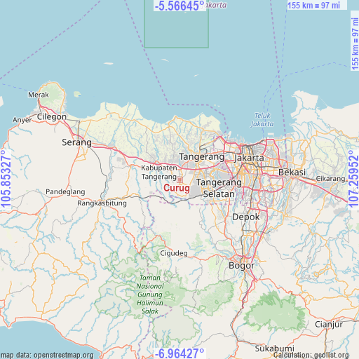
Curug GPS coordinates[2]
6° 15' 56.988" South, 106° 33' 23.004" East
| Map corner | latitude | longitude |
|---|---|---|
| Upper-left | -5.56645°, | 105.85327° |
| Center: | -6.26583°, | 106.55639° |
| Lower-right: | -6.96427°, | 107.25952° |
| Map W x H: | 155.4×155.4 km | = 96.6×96.6mi |
| max Lat: | 5.88969° ⇑13% North |
| Curug: | -6.26583° |
| min Lat: | ⇓87% South -10.934° |
| min Long | Curug | max Long |
| 95.1345° | 106.55639° | 140.9419° |
| W 12.7%⇐ | ⇒87.3% E |
Elevation
Elevation of Curug is 39 m = 128 ft, and this is 190.7 m = 626 ft below average elevation for this country.
| Max E: |
3185 m = 10449 ft | 66.4% |
| Avg. | 229.7 m = 754 ft | |
| Curug | 39 m = 128 ft | |
Min E: |
-1 m = -3 ft | 33.6% |
See also: Curug elevation on elevation.city.
Geographical zone
Curug is located in South Torrid zone (between Equator and Tropic of Capricorn). Distance of Equator is 696.7 km =432.9 mi to North.| Distance of | km | miles | from Curug |
|---|---|---|---|
| Equator | 696.7 | 432.9 | to North |
| Tropic Capricorn | 1909.2 | 1186.3 | to South |
| Antarctic Circle | 6704.5 | 4166 | to South |
| South Pole | 9310.4 | 5785.2 | to South |


Nearby cities:
15 places around Curug: (largest is in red/bold)
• Cikupa
6.2 km =3.9 mi,  301°
301°
• Ciputat
15.7 km =9.8 mi,  78°
78°
• Garisul
27.5 km =17.1 mi,  194°
194°
• Kresek
24.6 km =15.3 mi,  307°
307°
• Pamulang
21.9 km =13.6 mi,  113°
113°
• Pangradin Satu
28.4 km =17.6 mi,  197°
197°
• Parung
26.1 km =16.2 mi,  131°
131°
• Pasarkemis
11 km =6.8 mi,  344°
344°
• Sawangan
28.5 km =17.7 mi,  122°
122°
• Sepatan
16.5 km =10.3 mi,  7°
7°
• Serpong
13.2 km =8.2 mi, 115°
• South Tangerang
18 km =11.2 mi,  98°
98°
• Tangerang
12.7 km =7.9 mi,  39°
39°
• Teluknaga
20.6 km =12.8 mi,  25°
25°
• Tigaraksa
6.3 km =3.9 mi, 311°
Sources, notices
• [Note1] Compared only with cities in Indonesia existing in our database
• [Src1] Map data: © OpenStreetMap contributors (CC-BY-SA)
• [Src2] Other city data from geonames.org with taken over terms of usage.
• [Src3] Geographical zone / Annual Mean Temperature by Robert A. Rohde @ Wikipedia
