Tangerang geodata
Tangerang (Banten) is a populated place; located in Indonesia in Asia/Jakarta (GMT+7) time zone. With population of 1,372,124 people, there are 6 cities with bigger population in this country. Compared to other cities in Indonesia, 87.6% of cities are located further ↓South; 87% of cities are located further →East and 80.9% of cities have higher elevation than Tangerang. Note1


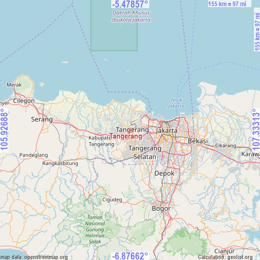
Tangerang GPS coordinates[2]
6° 10' 41.016" South, 106° 37' 48" East
| Map corner | latitude | longitude |
|---|---|---|
| Upper-left | -5.47857°, | 105.92688° |
| Center: | -6.17806°, | 106.63° |
| Lower-right: | -6.87662°, | 107.33313° |
| Map W x H: | 155.4×155.5 km | = 96.6×96.6mi |
| max Lat: | 5.88969° ⇑12.4% North |
| Tangerang: | -6.17806° |
| min Lat: | ⇓87.6% South -10.934° |
| min Long | Tangerang | max Long |
| 95.1345° | 106.63° | 140.9419° |
| W 13%⇐ | ⇒87% E |
Elevation
Elevation of Tangerang is 18 m = 59 ft, and this is 211.7 m = 695 ft below average elevation for this country.
| Max E: |
3185 m = 10449 ft | 80.9% |
| Avg. | 229.7 m = 754 ft | |
| Tangerang | 18 m = 59 ft | |
Min E: |
-1 m = -3 ft | 19.1% |
See also: Tangerang elevation on elevation.city.
Geographical zone
Tangerang is located in South Torrid zone (between Equator and Tropic of Capricorn). Distance of Equator is 686.9 km =426.8 mi to North.| Distance of | km | miles | from Tangerang |
|---|---|---|---|
| Equator | 686.9 | 426.8 | to North |
| Tropic Capricorn | 1919 | 1192.4 | to South |
| Antarctic Circle | 6714.2 | 4172 | to South |
| South Pole | 9320.1 | 5791.2 | to South |


Nearby cities:
15 places around Tangerang: (largest is in red/bold)
• Cikupa
14.9 km =9.3 mi,  244°
244°
• Ciputat
9.8 km =6.1 mi,  132°
132°
• Curug
12.7 km =7.9 mi,  219°
219°
• Depok
32.3 km =20.1 mi,  139°
139°
• Jakarta
24.1 km =15 mi,  99°
99°
• Kresek
28.2 km =17.5 mi,  280°
280°
• Pamulang
21.9 km =13.6 mi,  146°
146°
• Parung
29.4 km =18.3 mi,  157°
157°
• Pasarkemis
11.1 km =6.9 mi,  274°
274°
• Sawangan
29.7 km =18.5 mi, 147°
• Sepatan
9 km =5.6 mi,  317°
317°
• Serpong
15.9 km =9.9 mi,  166°
166°
• South Tangerang
15.7 km =9.8 mi, 141°
• Teluknaga
8.8 km =5.5 mi,  5°
5°
• Tigaraksa
14 km =8.7 mi,  246°
246°
Sources, notices
• [Note1] Compared only with cities in Indonesia existing in our database
• [Src1] Map data: © OpenStreetMap contributors (CC-BY-SA)
• [Src2] Other city data from geonames.org with taken over terms of usage.
• [Src3] Geographical zone / Annual Mean Temperature by Robert A. Rohde @ Wikipedia
