Kedewan geodata
Kedewan (East Java) is a seat of a fourth-order administrative division; located in Indonesia in Asia/Jakarta (GMT+7) time zone. In our database, there are 407 cities with bigger population. Compared to other cities in Indonesia, 63.5% of cities are located further ↓South; 55.6% of cities are located further →East and 52.3% of cities have lower elevation than Kedewan. Note1


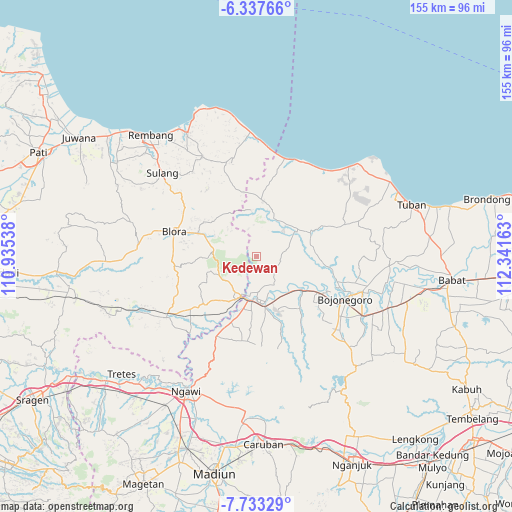
Kedewan GPS coordinates[2]
7° 2' 9.6" South, 111° 38' 18.6" East
| Map corner | latitude | longitude |
|---|---|---|
| Upper-left | -6.33766°, | 110.93538° |
| Center: | -7.036°, | 111.6385° |
| Lower-right: | -7.73329°, | 112.34163° |
| Map W x H: | 155.2×155.2 km | = 96.4×96.4mi |
| max Lat: | 5.88969° ⇑36.5% North |
| Kedewan: | -7.036° |
| min Lat: | ⇓63.5% South -10.934° |
| min Long | Kedewan | max Long |
| 95.1345° | 111.6385° | 140.9419° |
| W 44.4%⇐ | ⇒55.6% E |
Elevation
Elevation of Kedewan is 111 m = 364 ft, and this is 118.7 m = 389 ft below average elevation for this country.
| Max E: |
3185 m = 10449 ft | 47.7% |
| Avg. | 229.7 m = 754 ft | |
| Kedewan | 111 m = 364 ft | |
Min E: |
-1 m = -3 ft | 52.3% |
See also: Indonesia elevation on elevation.city.
Geographical zone
Kedewan is located in South Torrid zone (between Equator and Tropic of Capricorn). Distance of Equator is 782.3 km =486.1 mi to North.| Distance of | km | miles | from Kedewan |
|---|---|---|---|
| Equator | 782.3 | 486.1 | to North |
| Tropic Capricorn | 1823.6 | 1133.1 | to South |
| Antarctic Circle | 6618.8 | 4112.7 | to South |
| South Pole | 9224.7 | 5732 | to South |


Nearby cities:
15 places around Kedewan: (largest is in red/bold)
• Banyuurip
7.2 km =4.5 mi,  114°
114°
• Bate
7 km =4.3 mi,  50°
50°
• Kablukan
9.7 km =6 mi, 53°
• Kawengan
6.1 km =3.8 mi,  130°
130°
• Kejuron
8.9 km =5.5 mi,  35°
35°
• Klakeh
8.2 km =5.1 mi, 38°
• Krajan Jamprong
8.8 km =5.5 mi,  343°
343°
• Leran
9 km =5.6 mi,  80°
80°
• Medalem
9.1 km =5.7 mi,  65°
65°
• Nglateng Barat
9 km =5.6 mi,  3°
3°
• Ngrowo
4.8 km =3 mi,  195°
195°
• Sarang
6.9 km =4.3 mi,  85°
85°
• Tambakmerak
9.3 km =5.8 mi,  162°
162°
• Wonocolo
3.9 km =2.4 mi, 114°
• Wonosari
9 km =5.6 mi,  116°
116°
Sources, notices
• [Note1] Compared only with cities in Indonesia existing in our database
• [Src1] Map data: © OpenStreetMap contributors (CC-BY-SA)
• [Src2] Other city data from geonames.org with taken over terms of usage.
• [Src3] Geographical zone / Annual Mean Temperature by Robert A. Rohde @ Wikipedia
