Sragen geodata
Sragen (Central Java) is a seat of a second-order administrative division; located in Indonesia in Asia/Jakarta (GMT+7) time zone. With population of 71,522 people, there are 177 cities with bigger population in this country. Compared to other cities in Indonesia, 54% of cities are located further ↑North; 64.7% of cities are located further →East and 53.7% of cities have higher elevation than Sragen. Note1


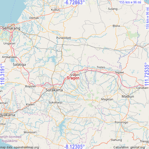
Sragen GPS coordinates[2]
7° 25' 35.004" South, 111° 1' 19.992" East
| Map corner | latitude | longitude |
|---|---|---|
| Upper-left | -6.72863°, | 110.3191° |
| Center: | -7.42639°, | 111.02222° |
| Lower-right: | -8.12305°, | 111.72535° |
| Map W x H: | 155×155 km | = 96.3×96.3mi |
| max Lat: | 5.88969° ⇑54% North |
| Sragen: | -7.42639° |
| min Lat: | ⇓46% South -10.934° |
| min Long | Sragen | max Long |
| 95.1345° | 111.02222° | 140.9419° |
| W 35.3%⇐ | ⇒64.7% E |
Elevation
Elevation of Sragen is 90 m = 295 ft, and this is 139.7 m = 458 ft below average elevation for this country.
| Max E: |
3185 m = 10449 ft | 53.7% |
| Avg. | 229.7 m = 754 ft | |
| Sragen | 90 m = 295 ft | |
Min E: |
-1 m = -3 ft | 46.3% |
See also: Sragen elevation on elevation.city.
Geographical zone
Sragen is located in South Torrid zone (between Equator and Tropic of Capricorn). Distance of Equator is 825.7 km =513.1 mi to North.| Distance of | km | miles | from Sragen |
|---|---|---|---|
| Equator | 825.7 | 513.1 | to North |
| Tropic Capricorn | 1780.2 | 1106.2 | to South |
| Antarctic Circle | 6575.4 | 4085.8 | to South |
| South Pole | 9181.3 | 5705 | to South |


Nearby cities:
15 places around Sragen: (largest is in red/bold)
• Baki
33.5 km =20.8 mi,  231°
231°
• Colomadu
32.3 km =20.1 mi,  248°
248°
• Delanggu
42.9 km =26.7 mi,  240°
240°
• Gatak
39.5 km =24.5 mi, 242°
• Grogol
29.7 km =18.5 mi, 229°
• Jaten
21.7 km =13.5 mi,  219°
219°
• Karanganyar
21 km =13 mi,  204°
204°
• Kartasura
34.3 km =21.3 mi, 246°
• Magetan
42.6 km =26.5 mi,  126°
126°
• Ngemplak
36.4 km =22.6 mi, 247°
• Purwodadi
39.5 km =24.5 mi,  342°
342°
• Selogiri
43.2 km =26.8 mi, 203°
• Sukoharjo
34.1 km =21.2 mi, 216°
• Surakarta
25.5 km =15.8 mi, 235°
• Wonogiri
44.6 km =27.7 mi,  194°
194°
Sources, notices
• [Note1] Compared only with cities in Indonesia existing in our database
• [Src1] Map data: © OpenStreetMap contributors (CC-BY-SA)
• [Src2] Other city data from geonames.org with taken over terms of usage.
• [Src3] Geographical zone / Annual Mean Temperature by Robert A. Rohde @ Wikipedia
