Galesong geodata
Galesong (South Sulawesi) is a populated place; located in Indonesia in Asia/Makassar (GMT+8) time zone. With population of 83,050 people, there are 157 cities with bigger population in this country. Compared to other cities in Indonesia, 88.4% of cities are located further ↓South; 81.5% of cities are located further ←West and 87.7% of cities have higher elevation than Galesong. Note1


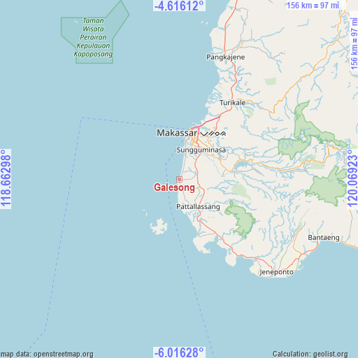
Galesong GPS coordinates[2]
5° 18' 59.76" South, 119° 21' 57.96" East
| Map corner | latitude | longitude |
|---|---|---|
| Upper-left | -4.61612°, | 118.66298° |
| Center: | -5.3166°, | 119.3661° |
| Lower-right: | -6.01628°, | 120.06923° |
| Map W x H: | 155.7×155.7 km | = 96.7×96.7mi |
| max Lat: | 5.88969° ⇑11.6% North |
| Galesong: | -5.3166° |
| min Lat: | ⇓88.4% South -10.934° |
| min Long | Galesong | max Long |
| 95.1345° | 119.3661° | 140.9419° |
| W 81.5%⇐ | ⇒18.5% E |
Elevation
Elevation of Galesong is 12 m = 39 ft, and this is 217.7 m = 714 ft below average elevation for this country.
| Max E: |
3185 m = 10449 ft | 87.7% |
| Avg. | 229.7 m = 754 ft | |
| Galesong | 12 m = 39 ft | |
Min E: |
-1 m = -3 ft | 12.3% |
See also: Galesong elevation on elevation.city.
Geographical zone
Galesong is located in South Torrid zone (between Equator and Tropic of Capricorn). Distance of Equator is 591.2 km =367.4 mi to North.| Distance of | km | miles | from Galesong |
|---|---|---|---|
| Equator | 591.2 | 367.4 | to North |
| Tropic Capricorn | 2014.8 | 1251.9 | to South |
| Antarctic Circle | 6810 | 4231.5 | to South |
| South Pole | 9415.9 | 5850.8 | to South |


Nearby cities:
15 places around Galesong: (largest is in red/bold)
• Bantaeng
69.6 km =43.2 mi,  111°
111°
• Barru
104.4 km =64.9 mi,  15°
15°
• Bulubulu
110.9 km =68.9 mi,  66°
66°
• Bulukumba
94.1 km =58.5 mi, 106°
• Camming
96.7 km =60.1 mi,  54°
54°
• Jeneponto
58.2 km =36.2 mi,  133°
133°
• Makassar
20.1 km =12.5 mi, 21°
• Maros
41.4 km =25.7 mi,  33°
33°
• Matango
102.2 km =63.5 mi,  44°
44°
• Palattae
91.2 km =56.7 mi, 65°
• Pangkajene
57 km =35.4 mi, 20°
• Sinjai
100.5 km =62.4 mi,  77°
77°
• Sungguminasa
16.3 km =10.1 mi, 35°
• Takalar
14.5 km =9 mi,  146°
146°
• Watansoppeng
121.6 km =75.6 mi, 28°
Sources, notices
• [Note1] Compared only with cities in Indonesia existing in our database
• [Src1] Map data: © OpenStreetMap contributors (CC-BY-SA)
• [Src2] Other city data from geonames.org with taken over terms of usage.
• [Src3] Geographical zone / Annual Mean Temperature by Robert A. Rohde @ Wikipedia
