Palattae geodata
Palattae (South Sulawesi) is a seat of a third-order administrative division; located in Indonesia in Asia/Makassar (GMT+8) time zone. In our database, there are 407 cities with bigger population. Compared to other cities in Indonesia, 88.7% of cities are located further ↓South; 83.1% of cities are located further ←West and 59.2% of cities have lower elevation than Palattae. Note1


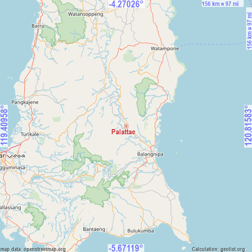
Palattae GPS coordinates[2]
4° 58' 15.96" South, 120° 6' 45.72" East
| Map corner | latitude | longitude |
|---|---|---|
| Upper-left | -4.27026°, | 119.40958° |
| Center: | -4.9711°, | 120.1127° |
| Lower-right: | -5.67119°, | 120.81583° |
| Map W x H: | 155.8×155.8 km | = 96.8×96.8mi |
| max Lat: | 5.88969° ⇑11.3% North |
| Palattae: | -4.9711° |
| min Lat: | ⇓88.7% South -10.934° |
| min Long | Palattae | max Long |
| 95.1345° | 120.1127° | 140.9419° |
| W 83.1%⇐ | ⇒16.9% E |
Elevation
Elevation of Palattae is 156 m = 512 ft, and this is 73.7 m = 242 ft below average elevation for this country.
| Max E: |
3185 m = 10449 ft | 40.8% |
| Avg. | 229.7 m = 754 ft | |
| Palattae | 156 m = 512 ft | |
Min E: |
-1 m = -3 ft | 59.2% |
See also: Indonesia elevation on elevation.city.
Geographical zone
Palattae is located in South Torrid zone (between Equator and Tropic of Capricorn). Distance of Equator is 552.7 km =343.4 mi to North.| Distance of | km | miles | from Palattae |
|---|---|---|---|
| Equator | 552.7 | 343.4 | to North |
| Tropic Capricorn | 2053.2 | 1275.8 | to South |
| Antarctic Circle | 6848.4 | 4255.4 | to South |
| South Pole | 9454.3 | 5874.6 | to South |


Nearby cities:
15 places around Palattae: (largest is in red/bold)
• Apala
45.7 km =28.4 mi,  29°
29°
• Bantaeng
66.5 km =41.3 mi,  195°
195°
• Bulubulu
19.8 km =12.3 mi,  70°
70°
• Bulukumba
64.8 km =40.3 mi,  173°
173°
• Camming
18.1 km =11.2 mi,  347°
347°
• Kadai
31.2 km =19.4 mi,  54°
54°
• Maros
59.9 km =37.2 mi,  266°
266°
• Matango
36.1 km =22.4 mi,  342°
342°
• Palakka
52.7 km =32.7 mi,  21°
21°
• Pangkajene
64.4 km =40 mi,  283°
283°
• Sinjai
23 km =14.3 mi,  137°
137°
• Sungguminasa
77.5 km =48.2 mi,  251°
251°
• Taccipi
52.3 km =32.5 mi,  8°
8°
• Watampone
53.7 km =33.4 mi, 26°
• Watansoppeng
73.3 km =45.5 mi, 339°
Sources, notices
• [Note1] Compared only with cities in Indonesia existing in our database
• [Src1] Map data: © OpenStreetMap contributors (CC-BY-SA)
• [Src2] Other city data from geonames.org with taken over terms of usage.
• [Src3] Geographical zone / Annual Mean Temperature by Robert A. Rohde @ Wikipedia
