Bantaeng geodata
Bantaeng (South Sulawesi) is a seat of a second-order administrative division; located in Indonesia in Asia/Makassar (GMT+8) time zone. In our database, there are 407 cities with bigger population. Compared to other cities in Indonesia, 88.2% of cities are located further ↓South; 82.6% of cities are located further ←West and 90.6% of cities have higher elevation than Bantaeng. Note1


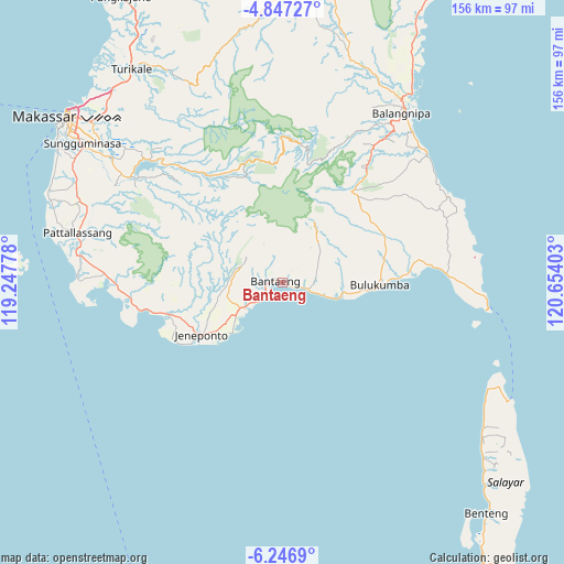
Bantaeng GPS coordinates[2]
5° 32' 51" South, 119° 57' 3.24" East
| Map corner | latitude | longitude |
|---|---|---|
| Upper-left | -4.84727°, | 119.24778° |
| Center: | -5.5475°, | 119.9509° |
| Lower-right: | -6.2469°, | 120.65403° |
| Map W x H: | 155.6×155.6 km | = 96.7×96.7mi |
| max Lat: | 5.88969° ⇑11.8% North |
| Bantaeng: | -5.5475° |
| min Lat: | ⇓88.2% South -10.934° |
| min Long | Bantaeng | max Long |
| 95.1345° | 119.9509° | 140.9419° |
| W 82.6%⇐ | ⇒17.4% E |
Elevation
Elevation of Bantaeng is 10 m = 33 ft, and this is 219.7 m = 721 ft below average elevation for this country.
| Max E: |
3185 m = 10449 ft | 90.6% |
| Avg. | 229.7 m = 754 ft | |
| Bantaeng | 10 m = 33 ft | |
Min E: |
-1 m = -3 ft | 9.4% |
See also: Indonesia elevation on elevation.city.
Geographical zone
Bantaeng is located in South Torrid zone (between Equator and Tropic of Capricorn). Distance of Equator is 616.8 km =383.3 mi to North.| Distance of | km | miles | from Bantaeng |
|---|---|---|---|
| Equator | 616.8 | 383.3 | to North |
| Tropic Capricorn | 1989.1 | 1236 | to South |
| Antarctic Circle | 6784.3 | 4215.6 | to South |
| South Pole | 9390.2 | 5834.8 | to South |


Nearby cities:
15 places around Bantaeng: (largest is in red/bold)
• Benteng
84.9 km =52.8 mi,  138°
138°
• Bulubulu
79.5 km =49.4 mi,  27°
27°
• Bulukumba
25.7 km =16 mi,  90°
90°
• Camming
83 km =51.6 mi,  9°
9°
• Galesong
69.6 km =43.2 mi,  291°
291°
• Jeneponto
26.6 km =16.5 mi,  237°
237°
• Kadai
92.9 km =57.7 mi, 27°
• Makassar
72.6 km =45.1 mi,  307°
307°
• Maros
73.3 km =45.5 mi,  325°
325°
• Matango
98.7 km =61.3 mi,  4°
4°
• Palattae
66.5 km =41.3 mi,  15°
15°
• Pangkajene
90.8 km =56.4 mi, 330°
• Sinjai
57.7 km =35.9 mi,  35°
35°
• Sungguminasa
67.7 km =42.1 mi, 305°
• Takalar
58.3 km =36.2 mi,  283°
283°
Sources, notices
• [Note1] Compared only with cities in Indonesia existing in our database
• [Src1] Map data: © OpenStreetMap contributors (CC-BY-SA)
• [Src2] Other city data from geonames.org with taken over terms of usage.
• [Src3] Geographical zone / Annual Mean Temperature by Robert A. Rohde @ Wikipedia
