Maros geodata
Maros (South Sulawesi) is a seat of a second-order administrative division; located in Indonesia in Asia/Makassar (GMT+8) time zone. With population of 30,000 people, there are 316 cities with bigger population in this country. Compared to other cities in Indonesia, 88.6% of cities are located further ↓South; 82% of cities are located further ←West and 92.1% of cities have higher elevation than Maros. Note1


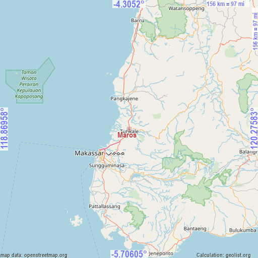
Maros GPS coordinates[2]
5° 0' 21.6" South, 119° 34' 21.72" East
| Map corner | latitude | longitude |
|---|---|---|
| Upper-left | -4.3052°, | 118.86958° |
| Center: | -5.006°, | 119.5727° |
| Lower-right: | -5.70605°, | 120.27583° |
| Map W x H: | 155.8×155.8 km | = 96.8×96.8mi |
| max Lat: | 5.88969° ⇑11.4% North |
| Maros: | -5.006° |
| min Lat: | ⇓88.6% South -10.934° |
| min Long | Maros | max Long |
| 95.1345° | 119.5727° | 140.9419° |
| W 82%⇐ | ⇒18% E |
Elevation
Elevation of Maros is 9 m = 30 ft, and this is 220.7 m = 724 ft below average elevation for this country.
| Max E: |
3185 m = 10449 ft | 92.1% |
| Avg. | 229.7 m = 754 ft | |
| Maros | 9 m = 30 ft | |
Min E: |
-1 m = -3 ft | 7.9% |
See also: Indonesia elevation on elevation.city.
Geographical zone
Maros is located in South Torrid zone (between Equator and Tropic of Capricorn). Distance of Equator is 556.6 km =345.9 mi to North.| Distance of | km | miles | from Maros |
|---|---|---|---|
| Equator | 556.6 | 345.9 | to North |
| Tropic Capricorn | 2049.3 | 1273.4 | to South |
| Antarctic Circle | 6844.6 | 4253 | to South |
| South Pole | 9450.4 | 5872.2 | to South |


Nearby cities:
15 places around Maros: (largest is in red/bold)
• Bantaeng
73.3 km =45.5 mi,  145°
145°
• Barru
66.2 km =41.1 mi,  4°
4°
• Bulubulu
79.2 km =49.2 mi,  82°
82°
• Camming
59.9 km =37.2 mi,  68°
68°
• Galesong
41.4 km =25.7 mi,  213°
213°
• Jeneponto
77 km =47.8 mi,  165°
165°
• Makassar
22.2 km =13.8 mi,  224°
224°
• Matango
62.1 km =38.6 mi,  51°
51°
• Palattae
59.9 km =37.2 mi,  86°
86°
• Pangkajene
19 km =11.8 mi,  351°
351°
• Sinjai
76.5 km =47.5 mi,  99°
99°
• Sungguminasa
25.2 km =15.7 mi, 212°
• Taccipi
87.6 km =54.4 mi, 50°
• Takalar
49 km =30.4 mi,  197°
197°
• Watansoppeng
80.5 km =50 mi,  25°
25°
Sources, notices
• [Note1] Compared only with cities in Indonesia existing in our database
• [Src1] Map data: © OpenStreetMap contributors (CC-BY-SA)
• [Src2] Other city data from geonames.org with taken over terms of usage.
• [Src3] Geographical zone / Annual Mean Temperature by Robert A. Rohde @ Wikipedia
