Bokat geodata
Bokat (Central Sulawesi) is a seat of a third-order administrative division; located in Indonesia in Asia/Makassar (GMT+8) time zone. In our database, there are 407 cities with bigger population. Compared to other cities in Indonesia, 96.3% of cities are located further ↓South; 86.6% of cities are located further ←West and 87.7% of cities have higher elevation than Bokat. Note1


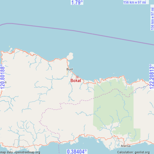
Bokat GPS coordinates[2]
1° 5' 13.56" North, 121° 30' 18" East
| Map corner | latitude | longitude |
|---|---|---|
| Upper-left | 1.79°, | 120.80188° |
| Center: | 1.0871°, | 121.505° |
| Lower-right: | 0.38404°, | 122.20813° |
| Map W x H: | 156.3×156.3 km | = 97.1×97.1mi |
| max Lat: | 5.88969° ⇑3.7% North |
| Bokat: | 1.0871° |
| min Lat: | ⇓96.3% South -10.934° |
| min Long | Bokat | max Long |
| 95.1345° | 121.505° | 140.9419° |
| W 86.6%⇐ | ⇒13.4% E |
Elevation
Elevation of Bokat is 12 m = 39 ft, and this is 217.7 m = 714 ft below average elevation for this country.
| Max E: |
3185 m = 10449 ft | 87.7% |
| Avg. | 229.7 m = 754 ft | |
| Bokat | 12 m = 39 ft | |
Min E: |
-1 m = -3 ft | 12.3% |
See also: Indonesia elevation on elevation.city.
Geographical zone
Bokat is located in North Torrid zone (between Equator and Tropic of Cancer). Distance of Equator is 120.9 km =75.1 mi to South.| Distance of | km | miles | from Bokat |
|---|---|---|---|
| North Pole | 9886.2 | 6143 | to North |
| Arctic Circle | 7280.3 | 4523.8 | to North |
| Tropic Cancer | 2485 | 1544.1 | to North |
| Equator | 120.9 | 75.1 | to South |


Nearby cities:
15 places around Bokat: (largest is in red/bold)
• Bunobogu
13 km =8.1 mi,  113°
113°
• Buol
11 km =6.8 mi,  315°
315°
• Isimu
158.6 km =98.5 mi, 108°
• Kali
12 km =7.5 mi,  314°
314°
• Kwandang
159.2 km =98.9 mi,  100°
100°
• Lamadong
10.6 km =6.6 mi,  288°
288°
• Lemito
61 km =37.9 mi,  173°
173°
• Marisa
84.3 km =52.4 mi,  145°
145°
• Molobulahe
129.2 km =80.3 mi, 113°
• Ogotua
138.7 km =86.2 mi,  264°
264°
• Payunga
171.1 km =106.3 mi, 109°
• Sidomulyo
132.7 km =82.5 mi, 111°
• Tilamuta
112.4 km =69.8 mi,  123°
123°
• Tinabogan
114 km =70.8 mi,  252°
252°
• Tolitoli
76.7 km =47.7 mi,  266°
266°
Sources, notices
• [Note1] Compared only with cities in Indonesia existing in our database
• [Src1] Map data: © OpenStreetMap contributors (CC-BY-SA)
• [Src2] Other city data from geonames.org with taken over terms of usage.
• [Src3] Geographical zone / Annual Mean Temperature by Robert A. Rohde @ Wikipedia
