Isimu geodata
Isimu (Gorontalo) is a seat of a third-order administrative division; located in Indonesia in Asia/Makassar (GMT+8) time zone. In our database, there are 407 cities with bigger population. Compared to other cities in Indonesia, 95.7% of cities are located further ↓South; 89.6% of cities are located further ←West and 70.7% of cities have higher elevation than Isimu. Note1


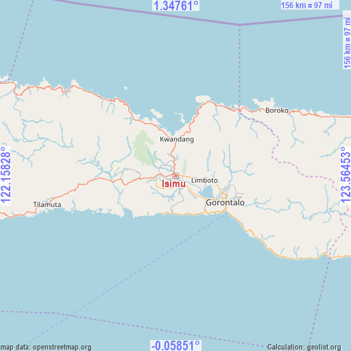
Isimu GPS coordinates[2]
0° 38' 40.56" North, 122° 51' 41.04" East
| Map corner | latitude | longitude |
|---|---|---|
| Upper-left | 1.34761°, | 122.15828° |
| Center: | 0.6446°, | 122.8614° |
| Lower-right: | -0.05851°, | 123.56453° |
| Map W x H: | 156.3×156.4 km | = 97.1×97.2mi |
| max Lat: | 5.88969° ⇑4.3% North |
| Isimu: | 0.6446° |
| min Lat: | ⇓95.7% South -10.934° |
| min Long | Isimu | max Long |
| 95.1345° | 122.8614° | 140.9419° |
| W 89.6%⇐ | ⇒10.4% E |
Elevation
Elevation of Isimu is 31 m = 102 ft, and this is 198.7 m = 652 ft below average elevation for this country.
| Max E: |
3185 m = 10449 ft | 70.7% |
| Avg. | 229.7 m = 754 ft | |
| Isimu | 31 m = 102 ft | |
Min E: |
-1 m = -3 ft | 29.3% |
See also: Indonesia elevation on elevation.city.
Geographical zone
Isimu is located in North Torrid zone (between Equator and Tropic of Cancer). Distance of Equator is 71.7 km =44.6 mi to South.| Distance of | km | miles | from Isimu |
|---|---|---|---|
| North Pole | 9935.4 | 6173.6 | to North |
| Arctic Circle | 7329.5 | 4554.3 | to North |
| Tropic Cancer | 2534.2 | 1574.7 | to North |
| Equator | 71.7 | 44.6 | to South |


Nearby cities:
15 places around Isimu: (largest is in red/bold)
• Bilungala
48.9 km =30.4 mi,  126°
126°
• Bolangitang
57.5 km =35.7 mi,  59°
59°
• Boroko
53.9 km =33.5 mi, 57°
• Gorontalo
25.3 km =15.7 mi,  118°
118°
• Kwandang
22 km =13.7 mi,  15°
15°
• Limboto
13.1 km =8.1 mi,  98°
98°
• Lolak
130.2 km =80.9 mi,  78°
78°
• Marisa
104.5 km =64.9 mi,  259°
259°
• Molibagu
127.9 km =79.5 mi, 102°
• Molobulahe
31.9 km =19.8 mi,  267°
267°
• Payunga
13.5 km =8.4 mi, 131°
• Pimpi
81 km =50.3 mi,  70°
70°
• Sidomulyo
27.4 km =17 mi, 271°
• Suwawa
34.1 km =21.2 mi,  111°
111°
• Tilamuta
58.7 km =36.5 mi, 257°
Sources, notices
• [Note1] Compared only with cities in Indonesia existing in our database
• [Src1] Map data: © OpenStreetMap contributors (CC-BY-SA)
• [Src2] Other city data from geonames.org with taken over terms of usage.
• [Src3] Geographical zone / Annual Mean Temperature by Robert A. Rohde @ Wikipedia
