Payunga geodata
Payunga (Gorontalo) is a seat of a third-order administrative division; located in Indonesia in Asia/Makassar (GMT+8) time zone. In our database, there are 407 cities with bigger population. Compared to other cities in Indonesia, 95.6% of cities are located further ↓South; 89.9% of cities are located further ←West and 79.9% of cities have higher elevation than Payunga. Note1


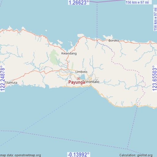
Payunga GPS coordinates[2]
0° 33' 47.52" North, 122° 57' 6.84" East
| Map corner | latitude | longitude |
|---|---|---|
| Upper-left | 1.26623°, | 122.24878° |
| Center: | 0.5632°, | 122.9519° |
| Lower-right: | -0.13992°, | 123.65503° |
| Map W x H: | 156.3×156.4 km | = 97.1×97.2mi |
| max Lat: | 5.88969° ⇑4.4% North |
| Payunga: | 0.5632° |
| min Lat: | ⇓95.6% South -10.934° |
| min Long | Payunga | max Long |
| 95.1345° | 122.9519° | 140.9419° |
| W 89.9%⇐ | ⇒10.1% E |
Elevation
Elevation of Payunga is 19 m = 62 ft, and this is 210.7 m = 691 ft below average elevation for this country.
| Max E: |
3185 m = 10449 ft | 79.9% |
| Avg. | 229.7 m = 754 ft | |
| Payunga | 19 m = 62 ft | |
Min E: |
-1 m = -3 ft | 20.1% |
See also: Indonesia elevation on elevation.city.
Geographical zone
Payunga is located in North Torrid zone (between Equator and Tropic of Cancer). Distance of Equator is 62.6 km =38.9 mi to South.| Distance of | km | miles | from Payunga |
|---|---|---|---|
| North Pole | 9944.4 | 6179.2 | to North |
| Arctic Circle | 7338.6 | 4560 | to North |
| Tropic Cancer | 2543.3 | 1580.3 | to North |
| Equator | 62.6 | 38.9 | to South |


Nearby cities:
15 places around Payunga: (largest is in red/bold)
• Bilungala
35.4 km =22 mi,  124°
124°
• Bolangitang
54.9 km =34.1 mi,  45°
45°
• Boroko
52 km =32.3 mi,  42°
42°
• Gorontalo
12.6 km =7.8 mi,  103°
103°
• Isimu
13.5 km =8.4 mi,  311°
311°
• Kwandang
30.5 km =19 mi,  352°
352°
• Limboto
7.7 km =4.8 mi,  22°
22°
• Lolak
122.6 km =76.2 mi,  73°
73°
• Marisa
113.2 km =70.3 mi,  264°
264°
• Molibagu
116.3 km =72.3 mi, 99°
• Molobulahe
42.6 km =26.5 mi,  280°
280°
• Pimpi
75.4 km =46.9 mi,  61°
61°
• Sidomulyo
38.6 km =24 mi, 284°
• Suwawa
22 km =13.7 mi, 98°
• Tilamuta
67.5 km =41.9 mi,  266°
266°
Sources, notices
• [Note1] Compared only with cities in Indonesia existing in our database
• [Src1] Map data: © OpenStreetMap contributors (CC-BY-SA)
• [Src2] Other city data from geonames.org with taken over terms of usage.
• [Src3] Geographical zone / Annual Mean Temperature by Robert A. Rohde @ Wikipedia
